Image:US pennsylvanian general.jpg
From Wikipedia, the free encyclopedia

US_pennsylvanian_general.jpg (500 × 353 pixel, file size: 22 KB, MIME type: image/jpeg)
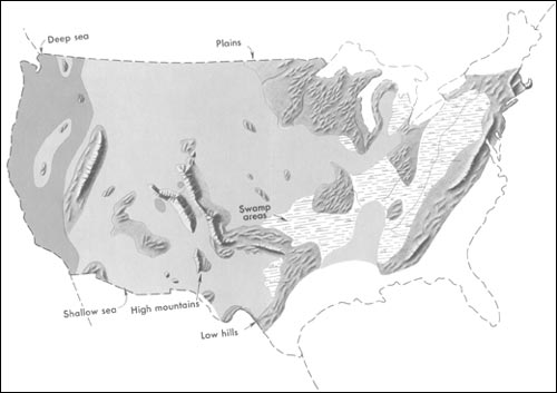
Generalized geographic map of the United States location in Middle Pennsylvanian time.
During the Carboniferous period, the contrast in the distribution of land and water from the ancient past to the present becomes more dramatic. The map shows the outline of the United States as it looked during the Pennsylvanian Period some 300 million years ago. It gives the appearance of reversing present-day geography.
A highland which lay to the east, south, and north supplied much of the sedimentary debris that was spread over the midwestern part of the United States. The Midwest was mainly a low swampy area in which scouring rushes and fern trees grew in profusion. Sediment was carried into the region from deltas to the east. From time to time, the level of the sea fluctuated -- possibly because of glacial conditions in the Southern Hemisphere. Swamps were flooded, and forests were destroyed. Slowly, layers rich in tree stumps, spores, branches, and leaves were deposited. Later, heat and pressure changed these layers into the coal beds that are so extensive in Illinois, Kentucky, Pennsylvania, West Virginia, and Tennessee. To the west, marine limestones, sandstones, and shales accumulated in shallow seas whose vast expanses were dotted with shoals and islands. Some of the very large islands were formed by the buckling and uplifting of parts of the Earth's crust.
This image is a work of a United States Geological Survey employee, taken or made during the course of the person's official duties. As a work of the United States Government, the image is in the public domain. For more information, see the USGS copyright policy.
http://pubs.usgs.gov/gip/continents/pennmap.jpg
File history
Legend: (cur) = this is the current file, (del) = delete
this old version, (rev) = revert to this old version.
Click on date to download the file or see the image uploaded on that date.
- (del) (cur) 02:48, 15 April 2005 . . SEWilco (Talk | contribs) . . 500×353 (22,509 bytes) (Generalized geographic map of the United States in Middle Pennsylvanian time. In the Coal Age, the contrast in the distribution of land and water from the ancient past to the present becomes more dramatic. The map shows the outline of the United )
- Edit this file using an external application
See the setup instructions for more information.

