Bild:LuxembourgPartitionsMap francais.jpg
Us der alemannische Wikipedia, der freie Dialäkt-Enzyklopedy

Keine höhere Auflösung vorhanden.
LuxembourgPartitionsMap_francais.jpg (433 × 588 Pixel, Dateigröße: 111 KB, MIME-Typ: image/jpeg)
| | Des Medium wird direkt vo Wikimedia Commons us ybunde. Aagabe zur Quelle un d'Lizenz cha mer dört uf dr Bildbeschrybigssyte finde. |
[edit] Summary
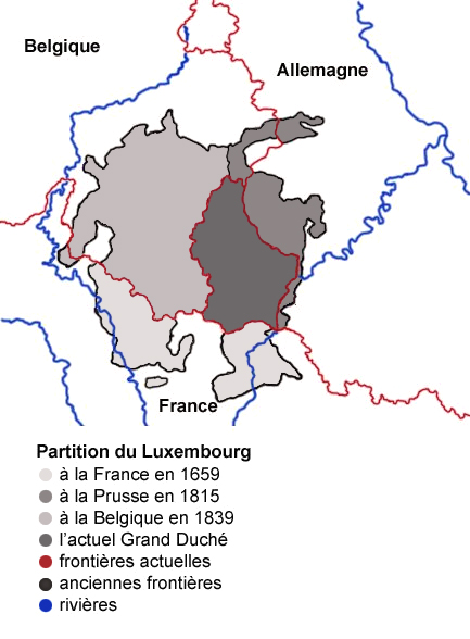
Map showing the partition of Luxembourg thorugh the centuries with french expanantions. Modification of the image LuxembourgPartitionsMap.png by user:QuartierLatin1968 14:10, 22 Apr 2005 (UTC). Author: user:Spanish_Inquisition Date: 3rd September 2006
[edit] Licensing
| I, the copyright holder of this work, hereby release it into the public domain. This applies worldwide. In case this is not legally possible: Afrikaans | Alemannisch | Aragonés | العربية | Asturianu | Български | Català | Česky | Cymraeg | Dansk | Deutsch | Ελληνικά | English | Español | Esperanto | Euskara | فارسی | Français | Galego | 한국어 | हिन्दी | Hrvatski | Ido | Bahasa Indonesia | Íslenska | Italiano | עברית | Kurdî / كوردي | Latina | Lietuvių | Magyar | Bahasa Melayu | Nederlands | Norsk (bokmål) | Norsk (nynorsk) | 日本語 | Polski | Português | Ripoarish | Română | Русский | Shqip | Slovenčina | Slovenščina | Српски | Svenska | ไทย | Türkçe | Українська | Tiếng Việt | Walon | 简体中文 | 繁體中文 | 粵語 | +/- |
Dateiversionen
Klicke auf einen Zeitpunkt, um diese Version zu laden.
| Version vom | Benutzer | Maße | Dateigröße | Kommentar | |
|---|---|---|---|---|---|
| aktuell | 10:11, 4. Aug. 2007 | Noelclem | 433×588 | 111 KB | |
| 09:22, 4. Aug. 2007 | Noelclem | 433×588 | 101 KB | ||
| 16:40, 3. Aug. 2007 | Iunity | 433×588 | 49 KB | correction orthographe | |
| 15:59, 3. Sep. 2006 | Spanish Inquisition | 433×588 | 85 KB | Map showing the partition of Luxembourg thorugh the centuries with french expanantions. Modification of the image LuxembourgPartitionsMap.png by user:QuartierLatin1968 14:10, 22 Apr 2005 (UTC). Author: user:Spanish_Inquisition Date: 3rd September 2006 |
Bildverweise
Di folgende Sytene händ en Link zu dem Bildli:

