صورة:Prince Edward Island-map.png
من ويكيبيديا، الموسوعة الحرة

لا توجد دقة أعلى متوفرة.
Prince_Edward_Island-map.png (280 × 230 بكسل، حجم الملف: 15 كيلوبايت، نوع الملف: image/png)
|
|
هذا الملف موجود في ويكيميديا كومنز، ويمكن استخدامه في مشاريع ويكيميديا الأخرى. لرؤية هذا الملف في ويكيميديا كومنز اتبع هذه الوصلة. |
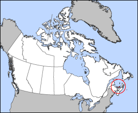
Map of Prince Edward Island
Projection: Lambert azimuthal equal-area
Geospatial data from: The Atlas of Canada, The National Atlas of the United States and U.S. Geological Survey
Cartographer: John Fowler
| I, the copyright holder of this work, hereby release it into the public domain. This applies worldwide. In case this is not legally possible: Afrikaans | Alemannisch | Aragonés | العربية | Asturianu | Български | Català | Česky | Cymraeg | Dansk | Deutsch | Ελληνικά | English | Español | Esperanto | Euskara | فارسی | Français | Galego | 한국어 | हिन्दी | Hrvatski | Ido | Bahasa Indonesia | Íslenska | Italiano | עברית | Kurdî / كوردي | Latina | Lietuvių | Magyar | Bahasa Melayu | Nederlands | Norsk (bokmål) | Norsk (nynorsk) | 日本語 | Polski | Português | Ripoarish | Română | Русский | Shqip | Slovenčina | Slovenščina | Српски | Svenska | ไทย | Türkçe | Українська | Tiếng Việt | Walon | 简体中文 | 繁體中文 | 粵語 | +/- |
تاريخ الملف
اضغط إحدى وصلات تاريخ/وقت لترى الملف كما كان في هذا الوقت.
| تاريخ/وقت | مستخدم | الأبعاد | حجم الملف | تعليق | |
|---|---|---|---|---|---|
| حالية | 12:17، 24 مارس 2005 | Voyager | 280×230 | 15 كيلوبايت | Map of Prince Edward Island Projection: Lambert azimuthal equal-area Geospatial data from: [http://atlas.gc.ca/ The Atlas of Canada], [http://www.nationalatlas.gov/ The National Atlas of the United States] and [http://www.usgs.gov U.S. Geological Survey |
وصلات
الصفحات التالية تحتوي على وصلة لهذه الصورة:

