Billede:Northern icesheet hg.png
Fra Wikipedia, den frie encyklopædi


Størrelse af vist billede: 800 × 587 pixel
Image in higher resolution (2236 × 1640 pixel, file size: 305 KB, MIME type: image/png)
| Denne fil er fra Wikimedia Commons, en samling af åbent indhold som Wikimedia Foundation er vært for. Beskrivelsen fra siden med beskrivelse af billedet er vist nedenfor. |
| Description |
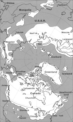
Northern hemisphere glaciation during the last ice ages. The set up of 3 to 4 km thick ice sheets caused a sea level lowering of about 120 m. Also the Alps and the Himalya were covered by glaciers. The limit of winter sea ice coverage was much more to the south. |
|---|---|
| Source |
own work; redrawn, supplemented and modified from a grafic of the United States Geological Survey |
| Date |
2000-04-07 |
| Author |
Hannes Grobe 23:06, 21 July 2006 (UTC), Alfred Wegener Institute for Polar and Marine Research, Bremerhaven, Germany |
| Permission |
Own work, share alike, attribution required (Creative Commons CC-BY-SA-2.5) |
| Other versions | in French : Image:Northern_icesheet-fr.png http://pubs.usgs.gov/gip/continents/map.jpg |
|
Billedehenvisninger
De følgende sider henviser til dette billede:

