Hurricane Opal
From Wikipedia, the free encyclopedia
| Category 4 hurricane (SSHS) | ||
|---|---|---|
 Hurricane Opal in the Gulf of Mexico |
||
| Formed | September 27, 1995 | |
| Dissipated | October 6, 1995 | |
| Highest winds |
|
|
| Lowest pressure | 916 mbar (hPa; 27.06 inHg) | |
| Fatalities | 59 direct, 10 indirect[citation needed] | |
| Damage | $3.9 billion (1995 USD) $5 billion (2006 USD) |
|
| Areas affected |
Guatemala, Yucatán Peninsula, Alabama, Florida Panhandle, Georgia, most of eastern North America | |
| Part of the 1995 Atlantic hurricane season |
||
Hurricane Opal was a major hurricane that formed in the Gulf of Mexico in September 1995. Opal was the ninth hurricane to form in the abnormally active 1995 Atlantic hurricane season. It struck the Yucatán Peninsula, then churned in the Gulf as the most powerful category four ever recorded in the Atlantic before making landfall a second time on the panhandle region of Florida as a 115 mph hurricane, devastating the Pensacola area. Opal also caused heavy damage in the Mid Atlantic states before dissipating.
Contents |
[edit] Storm history

The tropical wave that would become Hurricane Opal emerged from the west coast of Africa on September 11. The wave would stay disorganized, and did not begin strengthening until it neared the Yucatán Peninsula, becoming a tropical depression on September 27 while 70 nautical miles (130 km) south-southeast of Cozumel. The depression slowly moved over the Yucatan for the next several days, eventually emerging over the Bay of Campeche, where it was officially upgraded to Tropical Storm Opal.
After languishing for days and nearly dissipating due to the ocean-cooling effect of its own rainfall, it rapidly intensified to a hurricane and began moving north across the Gulf of Mexico. It deepened to a Category 4 hurricane with sustained winds of 150 mph and a central pressure of 916 mbar (the lowest ever recorded in a hurricane that never reached Category 5 intensity), possibly due to crossing the Loop Current.

During this period of rapid strengthening, a small eye formed with a diameter of only about 6 miles. The hurricane then underwent an eyewall replacement cycle combined with increasing wind shear, causing the pressure to rise steadily over the next few hours to 940 mb as the maximum sustained winds diminished to 125 mph.[1] Opal weakened still to 115 mph before its final landfall in Santa Rosa Island, Florida on October 4.
Opal remained a hurricane for nearly 12 hours after landfall, its rapid forward speed propelling it the entire length of Alabama before being downgraded to a tropical storm as it crossed into Tennessee. Over the following 12 hours, it was not downgraded to a tropical depression until it reached Ohio, and not declared extratropical until reaching Canada, where it still managed to bring squally conditions.
[edit] Preparations
Only four before-landfall watches and warnings were released in accordance with Hurricane Opal.[2] The first was on September 30 for the Northeast portion of the Yucatan Peninsula from Cozumel and Cancun to Progreso. This warning was discontinued late the next day. The second was a tropical storm warning issued on October 3 for Morgan City, Louisiana to just west of Pensacola, Florida. A hurricane warning was issued for Mobile, Alabama to Anclote Key, Florida on October 4.[2] This one warning was extended from Mobile, Alabama westward to the Mouth of the Mississippi River including coastal Mississippi. They were extended yet again for Grand Isle, Louisiana westward to just east of Morgan City, Louisiana including Metropolitan New Orleans. All remaining coastal Watches and Warnings discontinued on October 5 at 500 UTC.[2]
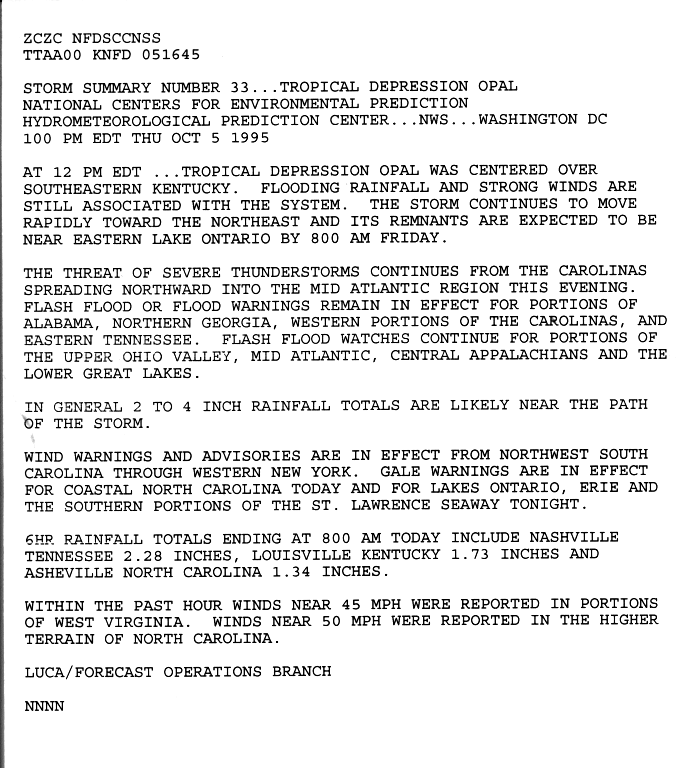
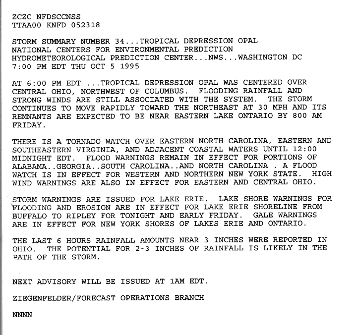
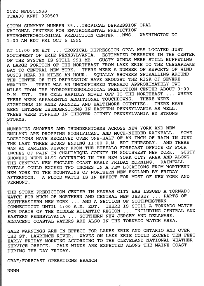
The post-landfall watches and warnings released in accordance with Opal were a flash flood warning released on October 5 for portions of Alabama, Northern Georgia, the western parts of North Carolina and South Carolina.[3] The warning also included eastern Tennessee. A flash flood watch was also in effect for portions of the Upper Ohio Valley, the Mid-Atlantic region, the central Appalachians and the lower Great Lakes. Wind warnings were in effect for northwestern South Carolina all the way to western New York.[3]A gale watch was also in effect for Lake Erie, Lake Ontario and the southern sections of the St. Lawrence Seaway.
Six hours later, the gale warnings over Lake Erie, Lake Ontario and the southern sections of the St. Lawrence Seaway was upgraded into a storm warning for Erie alone. The gale warning for the other two sections remained the same. The shoreline of Lake Erie was under a beach erosion warning from Buffalo, New York to Ripley, New York.[4] The Storm Prediction Center released a tornado watch on northern and central New Jersey, portions of New York and Connecticut on October 6.[5]
Significant non-surge areas of Escambia County south of US 98 are currently included in evacuation areas because of the potential for isolation by flooding.[6]
[edit] Impact
| Area | Deaths |
|---|---|
| Guatemala | 31 |
| Mexico | 19 |
| Florida | 1 |
| Alabama | 2 |
| Georgia | 14[7] |
| North Carolina | 3 |
| Total | 69 |
[edit] Mexico and Central America
Damage here was largely attributed to rainfall. Because Opal stalled on the coast of Mexico for several days as a weak tropical storm, flooding was reported across the country, killing 31 people in Guatemala and 19 in Mexico. Rain from the system produced flooding in Tabasco, Campeche, portions of Chiapas, Quintana Roo, and Yucatán.[8]
[edit] Florida
About 200 miles of Florida’s coastline felt effects from the very large Opal.[9]
Rainfalls in Florida peaked at 15.45 inches in Ellyson, 7.27 inches at Pensacola, 6.64 inches at Hurlburt Field and lower in over eight different locations. The highest gust recorded was a 145 mph gust at Hurlburt Field. Lower gusts were 115 mph (185 km/h) at Eglin Air Force Base and an 88 mph gust at Pensacola P.N.S. The highest sustained winds were 84 mph at Hurburt Field and 80 mph at Eglin Air Force Base. The two reported storm surges were 5-6 feet above normal at Apalachicola and 2-4 feet above normal at Sarasota.[2] Opal brought heavy surge to the area, 8-15 feet in some areas, comparing itself to Hurricane Eloise, which struck the same area at near equal strength in 1975.
Opal caused about $3 billion dollars in damage, making it the third costliest hurricane at the time when not

adjusted for inflation. Most of the structural damage occurred near the coastline on the Florida Peninsula, due to intense surge. Amazingly enough, nearly a mile of Highway 98 near Eglin Air Force Base was completely destroyed. The pavement was nearly replaced by mounds of sand left behind after storm surge.[10] Opal also spawned an F2 tornado that killed a young woman in Florida. None died as a direct result of storm surge. This is quite unusual, considering the strength and landfall location of Opal.
[edit] U.S. Gulf Coast
The peak rainfall from Opal in Alabama was 8.1 inches in Evergreen. Lower amounts include 7.48 in Mobile and 6.09 in Anniston. The highest gust reported was a 95 mph (155 km/h) gust in Fort Rucker and a secondary one at Maxwell Air Force Base with a gust of 90 mph (145 km/h). The highest sustained winds reported from Opal was 75 mph at Fort Rucker, 55 mph in Downtown Mobile and 47 mph at Maxwell Air Force Base and Montgomery.[2]
Numerous downed trees across much of the Southeastern United States left over 2 million without power. Alabama reported that 476,000 people were without power, which was a record at the time. This record number of power outages was beaten by Hurricane Ivan in 2004.[11] Damage was heavy all the way inland to Montgomery where winds reached 90 mph (145 km/h).
Highest rainfalls in Mississippi were five inches throughout the eastern side of the state with lower amouts going westward.[12]Tropical storm winds were reported along the Gulf Coast during the afternoon and early evening of October 4. Wind damage was mainly limited to downed tree limbs, power lines, and signs. Property damage cost estimated. One minor injury was reported in Harrison County due to flying debris. Damage in Mississippi totaled up to $75 thousand.[13]
In Louisiana, the only significant wind damage occurred in extreme south Plaquemine Parish where winds were estimated around 60 mph with gusts to hurricane force, with wind damage reported to some mobile homes and roofs of a few other structures. Tropical storm force winds, were reported in extreme south Lafourche Parish and Jefferson Parishes, as well as extreme east St. Bernarrowd Parish. Property damage cost estimated. Tides were generally two feet above normal in Lake Pontchartrain, and three to five feet above normal along the southeast Louisiana coast from Grand Isle eastward. Some low-lying coastal roads were flooded.[14]
Approximately 10,000 people evacuated from the southern, or lower portions, of Plaquemines, St. Bernarrowd, Lafourche, and Jefferson Parishes. The only significant gathering of persons in public shelters occurred in Plaquemine Parish, where 1,600 people were placed in public shelters.[14]
Although no direct injuries occurred from the hurricane, an indirect injury is attributed to the hurricane in a freak accident. A Jefferson Parish employee was injured while attempting to lower a large flag on October 4th. The employee, who was holding onto a rope attached a flag was tossed high into the air, and suffered severe injuries when he fell back to the ground. Total damage in Louisiana totaled out to $200,000.[14]
Breaking swells from Opal in Texas caused water to spill across at the usual wash-over points which damaged several vehicles.[15]
[edit] Southeastern United States
The peak rainfall in Georgia was 8.66 inches in Marietta, 8.08 in Peach Tree and 7.17 in West Atlanta. Southern Georgia only reported 1-3 inches of rain, while the northern part of the state reached about 5-7 inches. The peak wind gust in Georgia was a 79 mph gust in Marietta, a 70 mph gust in Columbus, and a 56 mph gust in the Atlanta-Hartsfield area.[12][16] High winds in Rabun County caused $5.0 million from the approach of Opal on October 5. The damage was worst in Rabun County where numerous trees were blown down. The wind damage was described as being worse than the Superstorm of 1993. Power was out for some people for at least a week.[17] More than 4000 trees were knocked down within the city of Atlanta alone. These trees fell across roads, and on power lines, homes, mobile homes, and automobiles. More than a half a dozen people were injured from falling trees in the early morning hours of October 5. There were more than 1200 telephone poles knocked down and almost 5,000 power lines snapped. Power crews from surrounding states helped to restore power to many, however, thousands of residences remained without power through the weekend.
An 80-foot gash was torn out of Interstate 285 between Roswell Road and the Glenridge Connector in Atlanta. Schools were closed on October 5 and October 6 throughout the cities of Atlanta, Marietta, and in Fulton, Coweta, Carroll and Douglas counties. 47 of 101 schools were closed in Dekalb county alone. Four State Parks were closed after Opal, Mocassin Creek Park, Black Rock Mountain, Vogel State Park, and Fort Mountain State Park. 273 stations reported many falling traffic lights. Agricultural experts estimated that damage to the pecan crop was about $50.0 million. Several rivers and creeks overflowed their banks.[18]

Beginning the evening of October 4, numerous power outages were reported in metro Atlanta, where sustained tropical storm conditions overnight (including gusts to nearly 70 mph;110 km/h) felled thousands of trees. Oaks were particularly susceptible, as their root systems were loosened by nearly two days included in a major disaster area.[7]
Fourteen deaths were reported in Georgia alone.[7]
A seven inch rainfall was recorded in extreme northwestern South Carolina and came in reducing amounts around the rest of the state.[12] Heavy rainfalls closed roads and bridges, causing $24 million in crop and property damage.[19]
A tornado in Chesterfield, South Carolina caused many trees to be blown down in the Carolina Sandhill National Wildlife Refuge. Trees were blown down in Orangeburg, one of those trees fell onto a car and totaled it. An F0 tornado spawned by one of Opal's bands downed a number of trees and power lines. Campers, vehicles, structures and boats were damaged in Greenville.[20]
In North Carolina, over 17 inches of rain fell. The rainfall included 9.89 inches in Robinson Creek and 8.95 inches in Highlands. The Robinson Creek rains spwaned flash flooding.[21] Officials in the state had the citizens boil their water before drinking it because of a possibility that floodwater may have entered purification plants.[22] A landslide triggered by Opal and damaged the Blue Ridge Parkway.[23] Opal triggered a debris flow in the Poplar Cove area of Macon County.[24] A flash flood from rainfall amounts typically ranged from four to six inches and closed roads and bridges were the result. The most serious flooding apparently occurred in Avery County where evacuations were required and tanks of propane were found floating in the Banner Elk River.[19]
Three deaths also occurred in the state. A man in Candler was killed when a falling tree destroyed his mobile home. Another man was killed near Marshall when a tree was blown onto him while he was helping cut other trees out of the roadway. 10 people were also injured by wind blown debris and from falling trees. Damage from high winds totaled up to $15 million.[25]

[edit] Mid-Atlantic United States
In Virginia, trees in the Shenandoah Valley and along the Allegheny Plateau were blown down by 40 mph winds at higher elevations. Over 7000 people were without power and damage in Virginia totaled to $5000. The National Park Service reported dozens of trees blown down along Skyline Drive in two counties.[26]
In the Great Smokey Mountains, power and phone service were out in many areas of the park. Newfound Gap road is closed and was probably remain closed for several days due to trees and a rockslide that were lying across it. Campers were asked to leave Elkmont Campground near Gatlinburg early yesterday because of high water.[27]
In Blue Ridge National Park, many sections of the parkway are closed because of trees that have fallen across the road. Flooding has occurred in the northern portion of the parkway. Linville Falls has been evacuated; the Asheville and Gillespie Gap Districts are closed. Rockslides and mudslides had also been reported due to Opal.[27]
In West Virginia, 0.5-1.5 inches of rain were reported causing some schools to let out early.[28] High winds associated with the remnants of Opal moved through southeast West Virginia on the 5th. High winds ranged between 35 and 45 mph with some gusts to near 55 mph. A numerous amount of trees, large branches and power lines and ripped shingles off of the roof of homes were ripped off in the wind. The vast majority of damage occurred at elevations above two thousand feet. Damage from the wind totaled out to $2000.[29] Large limbs were downed by high wind across from the remnants of Hurricane Opal in Preston County. Damage there totaled out to $1000.[30] Damage in West Virginia totaled out to only $5,000.
In Maryland, a large tree and its limbs along Interstate 495 near Bittinger were downed by high winds associated with the remnants of Opal. The damage from the fallen tree and its limbs totaled out to one thousand dollars.[31]As Opal weakened over land into a mesocyclone moving into Maryland, it spawned three tornadoes in Charles, Prince Georges, and Anne Arundel County. The first tornado tracked along State Route 425 between the towns of Ironside and Grayton. Along the tornado's path, several trees were uprooted or snapped; two sheds were destroyed and two others sustained roof damage. Windows were blown out of a barn and several vehicles. Ten thousand dollars in damage occurred.[32] The second and strongest tornado hit ground in Temple Hills, injuring 3 people after reaching a peak wind of 150 mph. 100 homes were damaged with 15 being condemned. The Potomac Electric Power reported 9000 people without power. Damage from the second tornado totaled out to $5 million.[33] The third and final tornado touched down in Odenton, became an F1 tornado and doing $250,000 in damage to the area. Eleven houses were damaged and about 10,000 people were without power in the whole district that the Baltimore Gas and Electric serves.[34]
[edit] Central United States
In Tennessee, rainfalls included about three to five inches in the central part of the state, one inch at the western part of the state and three to five in the eastern part of the state.[12]
Wind speeds at the higher elevations of the Appalachian Mountains were recorded at 70 mph whereas 40-50 mph gusts were more common at the lower elevations. Trees and power lines were down over much of the region. Over 70 miles of the Appalachian Trail was closed due to trees being down. A total of over 20,000 people were without power from Opal's wrath. The most damage occurred in Hamilton County, which had damage was estimated over a total of $1 million. Damage in Hamilton County include a circus was left stranded at a campground and needed to be evacuated. A number of residences and businesses were also surrounded by water and occupants were to be evacuated. Total damage in Tennessee totaled out at $2.02 million.[35]
In Kentucky, one to five inches of rain was reported throughout the state from Opal.[12] Total rainfall across the county ranged from 2.4 inches at the Louisville International Airport to 3.5 inches at Fern Creek Road south of the Gene Snyder Freeway. Several trees were knocked down and soils were saturated after Opal passed through.[36] A bridge washed out over Sulphur Creek and minor flooding was reported across Kentucky Route 80.[37]Elizabethtown and the Fort Knox area had several roads closed after Opal washed them out.[38]
In Michigan, Opal produced two to three inches of rain over the Middle Rouge River Basin from late afternoon through the evening on the 5th. As a result, the Middle Rouge River crested one foot over flood stage, causing the Edward Hines Drive to be closed off to traffic.[39]
High winds associated with the remains of Hurricane Opal affected the area during the late afternoon and early evening on the 5th. Strong northeast winds destroyed a new 200 foot, two-story pole barn on the Marine City Highway in Marine City. The storm also cut power to several areas, resulting in some school closings. The maximum wind gust at Detroit Metro Airport was a 38 mph gust, which was from the northeast. The damage from this incident totaled out to $15,000.[40]
The remnants of Opal passed across northeast Ohio and caused wind gusts up to 45 mph and sustained winds of 20 to 30 mph all across northern Ohio. Several automobiles were damaged by falling trees or limbs. Crops were damaged from the strong winds. A number of farms reported fields of corn blown over and ripe apples and other fruit being stripped from trees. Rainfall of 3.4 inches in less than 24 hours was measured at Mansfield and most areas averaged 1.5 to 2.5 inches during the same period. Flooding was localized and not significant since very dry conditions preceded the storm.[41]
Sustained northeast winds ahead of the storm reached 55 mph (80 km/h) all across the lake with gusts to 70 mph (110 km/h) producing waves of 10 to 14 feet. Minor to moderate beach and shore erosion occurred in many areas, especially the western end of the lake. Localized flooding occurred in communities with low lying areas along the lake. Boats were also grounded. Damage in Ohio totaled out to $205,000.[42]
[edit] Northeastern United States
In New Jersey, thunderstorms with heavy rain, averaging around 3.5 inches countywide, caused flooding of small streams and roadways including United States Route 46. The heavy rain was represented as the first significant dent in the drought that has affected northern New Jersey since September 1994. Storm totals included 6.69 inches in Waywayanda, 5.31 in Hackettstown, 4.51 inches in Oak Ridge, 4.20 inches in Clinton and 4.10 inches in Pequannock.
The remnants of Opal caused severe thunderstorm uprooted trees near Belvidere. Trees and wires were down in scattered parts of the county including Route 57 near the Tri-county Firehouse. Downed wires caused power outages in Hackettstown and Mansfield Township.[43]
The remnants of Hurricane Opal passed over northwest Pennsylvania on Thursday night (5th/6th) and caused wind gusts up to 50 mph and sustained winds of 20 to 30 mph. Heavy rains accompanied the storm and averaged 1.5 to 2.5 inches. Flooding was localized and not significant since drought conditions preceded the storm. The prolonged period of strong winds brought down trees and limbs along with some power lines. At least one automobile was damaged by a downed tree in Erie. Several farms reported fields of corn blown down and apples and other fruit being stripped from trees. The actual crop damage estimate was unknown.[44]
The remnants of Opal passed just to the west of Buffalo, New York on the 5th and 6th. Two to three inches of rain fell over much of the area with isolated amounts of near four inches over parts of the Western Southern Tier. Sustained winds were estimated between 35 and 40 mph, but the easterly winds did down some trees and power lines. In Oneida County, the high winds downed trees and wires in New York Mills, Waterville, Sylvan Beach, North Bay, Lee Center, Rome, McConnellsville and Verona. In Saratoga County a large tree limb was downed in Saratoga Springs which damaged four cars. Total damage in New York totaled to $35,000.[45][46]
A low pressure area which used to be Opal moved across Western and Northern New York late and into Vermont on the night of October 5 and the morning October 6. Damaging winds occurred across parts of Central and Northern Vermont but especially along the western slopes of the Green Mountains. Damaging winds downed trees and power lines across Essex, Orleans, Addison, Caledonia and Rutland Counties. In Essex County damage occurred in Canaan and Concord. Damage was also reported in Caledonia County, in Rutland County, in Clarendon and Chittenden and in Orleans County in Derby Center. Total damage in Vermont totaled out to $135,000.[47]
Heavy winds and rain associated with the remnants of Opal brought down trees and knocked out power in southwestern and northern New Hampshire. One person was injured in Marlborough when a large tree blew onto his moving pickup truck.[48]
In Maine, Heavy winds and rain associated with the remnants of Opal brought down trees and knocked out power in coastal areas of Southern Maine. Some beach erosion occurred in Saco. Strong winds ripped away boats from their moorings in the Midcoast towns of Camden and Rockland.[49]
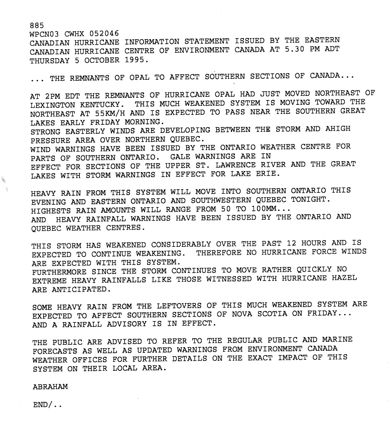
[edit] Canada
Wind and gale warnings were issued in southern Ontario and the upper St. Lawrence River in accordance with the remnants of Opal by the Canadian Hurricane Centre on September 5. The remnants also spawned a heavy rainfall warning by the Ontario Hurricane Center and the Quebec Hurricane Center for both provinces. The anticipated rain would not exist as the same as Hurricane Hazel 41 years before. The leftover system of Opal spawned a gale warning for Nova Scotia.[50] Rainfalls equaled out to .5 of an inch in Northwestern Ontario, .5 inches in southern parts of Quebec and .5 of an inch in New Brunswick. Rainfall stretched out to the area of Nova Scotia, but only .5 inch was reported.[51] Toronto had recorded winds of at least 52 mph and rainfall of about 3.09 inches.[52]
[edit] Retirement
- See also: List of retired Atlantic hurricanes
The name Opal was retired in the spring of 1996 and will never again be used in the Atlantic basin. It was replaced with Olga in the 2001 season.
[edit] Trivia
Opal was the first of only 5 storms to be assigned a name beginning with 'O' since hurricane naming began in the Atlantic in 1950. The other 4 are Olga of 2001, Odette of 2003, Otto of 2004 and Ophelia of 2005.
[edit] See also
[edit] References
- ^ http://www.weather.com/encyclopedia/tropical/archive/1995/storms.html
- ^ a b c d e Preliminary Report:Hurricane Opal
- ^ a b Hydrometeorolgical Prediction Center Advisory 1 - October 5 at 1 P.M.
- ^ Hydrometeorolgical Prediction Center Advisory 2 - October 5 at 7 P.M.
- ^ Hydrometeorolgical Prediction Center Advisory 3 - October 6 at 1 A.M.
- ^ HAZARDS AND VULNERABILITY DATA
- ^ a b c Preparedness Bulletin #2
- ^ Marilyn news (In spanish)
- ^ Geocities Article on Hurricane Opal
- ^ http://www.geocities.com/hurricanene/hurricaneopal.htm
- ^ Hurricane Ivan Situation Report #4
- ^ a b c d e Rainfall Totals: Hurricane Opal
- ^ Event-Hurricane Opal-: 04 Oct 1995, 0200 CST
- ^ a b c Event- Hurricane Opal- 04 Oct 1995, 2400 CST
- ^ Event- Beach Flood- 04 Oct 1995, 0800 CDT
- ^ Hurricane Opal Technological Report
- ^ Event-High Winds- 05 Oct 1995, 0300 EST
- ^ Event - Thunderstorm Winds - Oct 1995, 0600 EST
- ^ a b Event- Flash Flood- 05 Oct 1995, 0200 EST
- ^ [http://www.dnr.sc.gov/climate/sco/torn_stat_9096.html Significant Tornadoes in South Carolina 1990-2001]
- ^ Tropical Cyclones Affecting North Carolina
- ^ Opal ravages coastline
- ^ Geologic hazards in North Carolina — Landslides
- ^ PRELIMINARY FINDINGS OF THE SEPTEMBER 16, 2004 DEBRIS FLOW AT PEEKS CREEK, MACON COUNTY, NORTH CAROLINA
- ^ Event-High Winds-05 Oct 1995, 0300 EST
- ^ Event- High Winds- 05 Oct 1995, 1400 EST
- ^ a b Hurricane Opal Damage in the Smokies
- ^ Event- Heavy Rain- 05 Oct 1995, 0500 EST
- ^ Event- High Winds- 05 Oct 1995, 1030 EST
- ^ Event- High Winds- 05 Oct 1995, 1200 EST
- ^ Event- High Winds- 05 Oct 1995, 1200 EST
- ^ Event- Tornado- 05 Oct 1995, 1935 EST
- ^ Event-Tornado-05 Oct 1995, 1959 EST
- ^ Event- Tornado- 05 Oct 1995, 2031 EST
- ^ Event- High Winds- 05 Oct 1995, 0030 EST
- ^ Event- Gradient Winds- 05 Oct 1995, 0800 EDT
- ^ Event-Flash Flood- 5 Oct 1995, 0700 EDT
- ^ Event-Flash Flood- 05 Oct 1995, 0600 EDT
- ^ Event- River Flood- 05 Oct 1995, 2000 EST
- ^ Event- High Winds- 05 Oct 1995, 1600 EST
- ^ Event- High Winds- 05 Oct 1995, 0900 EST
- ^ Event- High Winds- 05 Oct 1995, 0900 EST
- ^ Event- Thunderstorm Winds- 05 Oct 1995, 2355 EST
- ^ Event- Heavy Rain- 05 Oct 1995, 1200 EST
- ^ Event- High Winds- 05 Oct 1995, 1925 EST
- ^ Event- High Winds- 05 Oct 1995, 2300 EST
- ^ Event- High Winds- 05 Oct 1995, 2200 EST
- ^ Event- High Winds- 05 Oct 1995, 2315 EST
- ^ Event- High Winds- 06 Oct 1995, 0300 EST
- ^ Canadian Hurricane Center Advisory 1
- ^ Rainfall - October 7
- ^ Significant Weather Events - Canada
[edit] External links
Categories: Articles with unsourced statements since March 2007 | All articles with unsourced statements | Articles to be split | Atlantic hurricanes | 1995 Atlantic hurricane season | Category 4 hurricanes | Retired Atlantic hurricanes | Florida hurricanes | Georgia hurricanes | Historic hurricanes in the United States | Hurricanes in Guatemala | Hurricanes in Tabasco | Hurricanes in Chiapas | Hurricanes in Campeche | Hurricanes in Yucatán | Hurricanes in Quintana Roo | 1995 in Mexico | 1995 meteorology | History of Atlanta

