Imagen:Transylvania.png
De Wikipedia, la enciclopedia libre

Transylvania.png (303 × 225 píxeles; tamaño de archivo: 10 KB; tipo MIME: image/png)
| | Éste es un fichero de Wikimedia Commons, un depósito de contenido libre hospedado por la Fundación Wikimedia. Más abajo se reproduce su página de descripción con la información sobre su origen y licencia. |
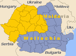
 Reason given for deletion request is: Map is missleading. The area is stretched over the region of Banat which is not part of Transylvania. Either correct it or delete it |
|
The deletion guidelines in various languages are: Alemannisch | Asturianu | Brezhoneg | Česky | Deutsch | English | Español | Français | Italiano | 日本語 | Русский | Português | Suomi | 简体中文 | +/-
Please note that this template is for REGULAR "Deletion Requests" to be discussed; it is NOT intended for speedy deletion. Here is the full syntax again, in case you misplaced it:
العربية | Česky | Deutsch | English | Español | Français | 日本語 | Nederlands | Norsk (bokmål) | Norsk (nynorsk) | Polski | Português | Русский | Türkçe | 简体中文 | 正體中文 | +/- |
Map of Romania with Transylvania highlighted
Source: Made by me
Also uploaded to en: by User:Bogdangiusca on July 12, 2003, GFDL

Enlaces a la imagen
Las siguientes páginas enlazan a esta imagen:

