Bild:LocationCentralMiddleAfrica.png
Us der alemannische Wikipedia, der freie Dialäkt-Enzyklopedy

Keine höhere Auflösung vorhanden.
LocationCentralMiddleAfrica.png (360 × 392 Pixel, Dateigröße: 14 KB, MIME-Typ: image/png)
| | Des Medium wird direkt vo Wikimedia Commons us ybunde. Aagabe zur Quelle un d'Lizenz cha mer dört uf dr Bildbeschrybigssyte finde. |
[edit] Summary
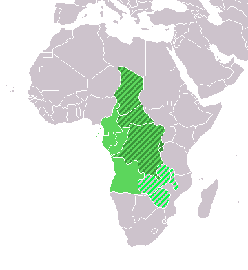
Map: Africa – Central/Middle Africa
- dark green: Central Africa (geographic)
- medium green: Middle Africa (UN subregion)
- light green/grey: Central African Federation (political: defunct)
[edit] Licensing
| I, the copyright holder of this work, hereby release it into the public domain. This applies worldwide. In case this is not legally possible: Afrikaans | Alemannisch | Aragonés | العربية | Asturianu | Български | Català | Česky | Cymraeg | Dansk | Deutsch | Ελληνικά | English | Español | Esperanto | Euskara | فارسی | Français | Galego | 한국어 | हिन्दी | Hrvatski | Ido | Bahasa Indonesia | Íslenska | Italiano | עברית | Kurdî / كوردي | Latina | Lietuvių | Magyar | Bahasa Melayu | Nederlands | Norsk (bokmål) | Norsk (nynorsk) | 日本語 | Polski | Português | Ripoarish | Română | Русский | Shqip | Slovenčina | Slovenščina | Српски | Svenska | ไทย | Türkçe | Українська | Tiếng Việt | Walon | 简体中文 | 繁體中文 | 粵語 | +/- |
Dateiversionen
Klicke auf einen Zeitpunkt, um diese Version zu laden.
| Version vom | Benutzer | Maße | Dateigröße | Kommentar | |
|---|---|---|---|---|---|
| aktuell | 09:35, 11. Dez. 2007 | Hoshie | 360×392 | 14 KB | added Cabinda and Montenegro |
| 15:04, 30. Dez. 2006 | Henrygb | 360×392 | 9 KB | Reverted to earlier revision | |
| 07:01, 1. Apr. 2006 | Aris Katsaris | 360×392 | 14 KB | cleaner map -- no need to include defunct federation which confuses the map's purpose. | |
| 18:40, 4. Feb. 2006 | E Pluribus Anthony | 360×392 | 9 KB | Map: Central/Middle Africa (location) |
Bildverweise
Di folgende Sytene händ en Link zu dem Bildli:

