Image:Nova Scotia-map.png
Fram Wikipedian

No higher resolution available.
Nova_Scotia-map.png (280 × 230 pixel, file size: 14 KB, MIME type: image/png)
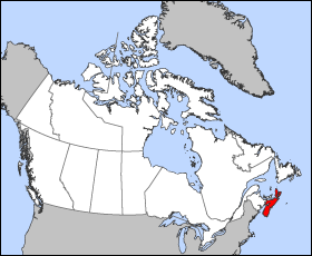
Map of Nova Scotia
Projection: Lambert azimuthal equal-area
Geospatial data from: The Atlas of Canada, The National Atlas of the United States and U.S. Geological Survey
Cartographer: John Fowler
| I, the copyright holder of this work, hereby release it into the public domain. This applies worldwide. In case this is not legally possible: Afrikaans | Alemannisch | Aragonés | العربية | Asturianu | Български | Català | Česky | Cymraeg | Dansk | Deutsch | Ελληνικά | English | Español | Esperanto | Euskara | فارسی | Français | Galego | 한국어 | हिन्दी | Hrvatski | Ido | Bahasa Indonesia | Íslenska | Italiano | עברית | Kurdî / كوردي | Latina | Lietuvių | Magyar | Bahasa Melayu | Nederlands | Norsk (bokmål) | Norsk (nynorsk) | 日本語 | Polski | Português | Ripoarish | Română | Русский | Shqip | Slovenčina | Slovenščina | Српски | Svenska | ไทย | Türkçe | Українська | Tiếng Việt | Walon | 简体中文 | 繁體中文 | 粵語 | +/- |
File history
Click on a date/time to view the file as it appeared at that time.
| Date/Time | Brūcend | Dimensions | File size | Comment | |
|---|---|---|---|---|---|
| current | 12:16, 24 Hrēþmōnaþ 2005 | Voyager | 280×230 | 14 KB | Map of Nova Scotia Projection: Lambert azimuthal equal-area Geospatial data from: [http://atlas.gc.ca/ The Atlas of Canada], [http://www.nationalatlas.gov/ The National Atlas of the United States] and [http://www.usgs.gov U.S. Geological Survey] Cartog |
Biliþbendas
Þā folgendan trametas bindaþ tō þissum biliðe:

