صورة:BarrierMay2005.png
من ويكيبيديا، الموسوعة الحرة

لا توجد دقة أعلى متوفرة.
BarrierMay2005.png (358 × 592 بكسل، حجم الملف: 7 كيلوبايت، نوع الملف: image/png)
|
|
هذا الملف موجود في ويكيميديا كومنز، ويمكن استخدامه في مشاريع ويكيميديا الأخرى. لرؤية هذا الملف في ويكيميديا كومنز اتبع هذه الوصلة. |
[edit] Summary
| Description |
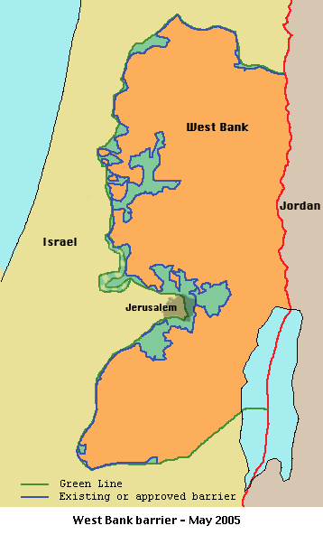
Español: Mapa de la barrera de Cisjordania
English: Israeli West Bank barrier, May 2005
|
||
|---|---|---|---|
| Source |
from en.wp |
||
| Date | |||
| Author | |||
| Permission (Reusing this image) |
|
||
| Other versions | Norwegian labels |
NOTE. The map is out of date. Here's a newer map: [1] Humus sapiens 10:07, 7 November 2006 (UTC)
 |
This map image should be recreated using vector graphics as an SVG file. This has several advantages; see Commons:Media for cleanup for more information. If an SVG form of this image is already available, please upload it. After uploading an SVG, replace this template with template {{Vector version available|new image name.svg}} in this image. |
|
العربية | Català | Česky | Dansk | Deutsch | English | Esperanto | Español | Français | 한국어 | Italiano | Magyar | Nederlands | 日本語 | Polski | Português | Română | Русский | Suomi | Svenska | Türkçe | Українська | Tiếng việt | 正體中文 | 简体中文 | +/- |
|
Image history of en:Image:BarrierMay2005.png:
(del) (cur) 02:10, 19 August 2005 . . Zero0000 . . 358x592 (7356 bytes) (Israeli separation barrier, May 2005.)
تاريخ الملف
اضغط إحدى وصلات تاريخ/وقت لترى الملف كما كان في هذا الوقت.
| تاريخ/وقت | مستخدم | الأبعاد | حجم الملف | تعليق | |
|---|---|---|---|---|---|
| حالية | 12:13، 30 مارس 2006 | Ideru | 358×592 | 7 كيلوبايت | Israeli West Bank barrier, May 2005 {{PD}} Source: en:Image:BarrierMay2005.png, there uploaded by en:User:Zero0000 Category:Zionism Category:Maps of Palestine Category:History of Israel Category:Maps of Israel [[Category:Securi |
وصلات
الصفحات التالية تحتوي على وصلة لهذه الصورة:

