صورة:Rzeczpospolita voivodships.png
من ويكيبيديا، الموسوعة الحرة

حجم هذا العرض: 765 × 600 بكسل
الصورة بدقة كاملة (2,000 × 1,568 بكسل، حجم الملف: 253 كيلوبايت، نوع الملف: image/png)
|
|
هذا الملف موجود في ويكيميديا كومنز، ويمكن استخدامه في مشاريع ويكيميديا الأخرى. لرؤية هذا الملف في ويكيميديا كومنز اتبع هذه الوصلة. |
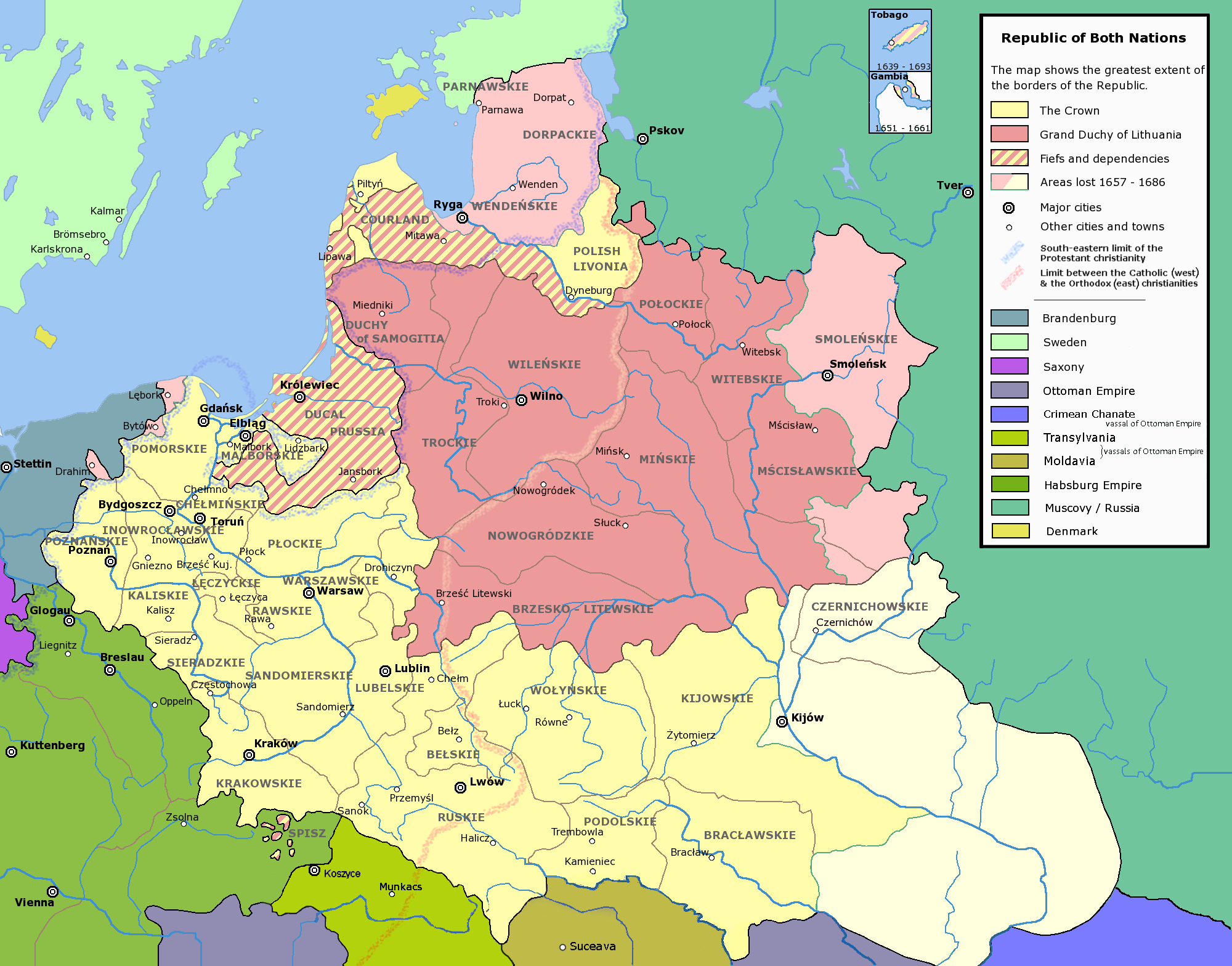
In Polish the voivodships and other units of administrative division are traditionally referred to with their adjective forms, i.e. Płock Voivodship is referred to as (Województwo) Płockie (Literally Plockian voivodship), Podole Voivodship as (Województwo) Podolskie (literally Podolian Voivodship) and so on.
The areas marked with light pink were lost to:
- Brandenburg in the treaties of Welawa and Bydgoszcz in 1657
- Sweden and Brandenburg in the treaty of Oliwa in 1660
- Muscovy in the Treaty of Andruszów in 1667
- Muscovy in the Grzymułtowski's Peace Treaty of 1686
Les noms polonais des unités administratives sont sous leur forme adjective. Par exemple, la voïvodie de Plock est nommée Województwo Płockie (litéralement la "Voïvodie Plockienne").
Les zones colorées en rose clair ont été cédées aux pays suivants:
- Brandebourg (traités de Welawa et Bydgoszcz en 1657
- Suède et Brandebourg (traité d'Oliwa en 1660)
- Grand-duché de Moscou (traités de Andruszów en 1667 et de Grzymułtowski en 1686)
The following is a list of maps created by Halibutt and uploaded to commons, as well as their present and projected derivatives.
| Parent Image | Image | Description | |||||||||||
|---|---|---|---|---|---|---|---|---|---|---|---|---|---|
| Maps by Halibutt | |||||||||||||
| Image:Rzeczpospolita.png | Image:Rzeczpospolita.png | The Republic in 17th and 18th century | |||||||||||
| Image:Rzeczpospolita 1600.png | The Republic after the Treaty of Dywilino | ||||||||||||
| Image:Rzeczpospolita voivodships.png | Voivodships of The Republic | ||||||||||||
| Image:Rzeczpospolita_Potop.png | The Republic during The Deluge and Chmielnicki Uprising, with major battles of the era marked | ||||||||||||
| Magnates and their lands and domains | |||||||||||||
| 1st • 2nd • 3rd | Partitions of Poland | ||||||||||||
| War of the constitution | |||||||||||||
| Image:Rzeczpospolita.xcf | SOURCE FILE - GIMP format | ||||||||||||
| Image:Poland 1939.png | Image:Poland 1939.png | Poland in 1939 | |||||||||||
| Image:Dywizje wrzesien 1.png | Order of Battle on September 1st, during the Polish Defence War of 1939 | ||||||||||||
| Image:Poland 1939.xcf | SOURCE FILE - GIMP format | ||||||||||||
| Image:Polska kontur bialy.png | Image:Polska kontur bialy.png | Contour map of Poland AD 1999, for use with various locator maps | |||||||||||
| Image:Rzeczpospolita 1920.png | Image:Rzeczpospolita 1920.png | Map of Poland 1918-1939, currently under development | |||||||||||
| Image:PBW March 1919.png | Polish-Bolshevik War - fronts in March of 1919 | ||||||||||||
| Image:PBW December 1919.png | Polish-Bolshevik War - fronts in December of 1919 | ||||||||||||
| Image:PBW June 1920.png | Polish-Bolshevik War - fronts in July of 1920 | ||||||||||||
| Image:PBW August 1920.png | Polish-Bolshevik War - fronts in August of 1920 | ||||||||||||
| Polish Defence War of 1939 | |||||||||||||
| Polish areas annexed by Germany, Lithuania, Slovakia and the Soviet Union | |||||||||||||
| German concentration camps in Poland | |||||||||||||
| Curzon line | |||||||||||||
| Major battles of the Polish-Bolshevik War | |||||||||||||
| names • no names | Polish/Czechoslovak/Lithuanian/German/Ukrainian claims in 1920's | ||||||||||||
| Image:Rzeczpospolita Central Lithuania.png | Central Lithuania | ||||||||||||
| Image:Rzeczpospolita Lithuania claims.png | Central Lithuania as compared with other Lithuanian claims | ||||||||||||
| Image:Rzeczpospolita 1789-1920.png | Post-1922 borders compared with the territory of Poland before the partitions | ||||||||||||
| Warsaw Uprising and the Operation Tempest | |||||||||||||
| Poland partitioned between the Soviets and the Germans | |||||||||||||
| Image:Rzeczpospolita 1939 Polish divisions.png | Polish divisions on September 1, 1939 | ||||||||||||
| Home Army inspectorates | |||||||||||||
| Image:Rzeczpospolita 1920.xcf | SOURCE FILE - GIMP format | ||||||||||||
Since the legal status of the above comment has been questioned, I hereby grant anyone the right to treat it as either a standard copyright notice, invariant section, legal statement, legal advice, friendly suggestion or a mere comment, depending on his or hers own choice. |
| Permission is granted to copy, distribute and/or modify this document under the terms of the GNU Free Documentation License, Version 1.2 or any later version published by the Free Software Foundation; with no Front-Cover Texts, and no Back-Cover Texts but with Invariant Sections (as per above). |  |
| This is a featured picture on Wikimedia Commons. We think it is one of the finest images on Commons; see its nomination. If you have an image of similar quality that can be published under a suitable copyright license, be sure to upload it, tag it, and nominate it. |
| This image was selected as a picture of the day for April 5, 2006. It was captioned as followed:
Česky: Vojvodství Republiky obou národů (polsko-litevské unie).
Français : Voïvodies (régions administrative) de l'union polono-lituanienne.
Polski: Podział administracyjny Rzeczpospolitej Obojga Narodów
Português: Voivodias da comunidade comum polaco-lituana.
Русский: Воеводства Речи Посполитой
ไทย: เขตการปกครองของเครือรัฐโปแลนด์-ลิทัวเนีย
|
تاريخ الملف
اضغط إحدى وصلات تاريخ/وقت لترى الملف كما كان في هذا الوقت.
| تاريخ/وقت | مستخدم | الأبعاد | حجم الملف | تعليق | |
|---|---|---|---|---|---|
| حالية | 07:57، 7 فبراير 2007 | Tene | 2,000×1,568 | 253 كيلوبايت | Optimised (0) |
| 19:23، 13 ديسمبر 2004 | Halibutt | 2,000×1,568 | 397 كيلوبايت | Ok, final version at last (unless you have some more comments or suggestions) | |
| 07:47، 10 ديسمبر 2004 | Halibutt | 2,000×1,568 | 386 كيلوبايت | Voivodships of the Republic of Both Nations<br><br> A derivative work of Image:Rzeczpospolita.png<br>Please refer to that graphic's page for more detailed description, licensing information and such.<br>{{User:Halibutt/GFDL}}<br>{{User:Halibutt/maps} |
وصلات
الصفحات التالية تحتوي على وصلة لهذه الصورة:

