Image:LocationIran.png
From Wikipedia

No higher resolution available.
LocationIran.png (250 × 115 pixel, file size: 7 KB, MIME type: image/png)
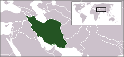
Location map for the Iran.
Originally created for English Wikipedia by Vardion.
| This image has been (or is hereby) released into the public domain by its author, Vardion at the English Wikipedia project. This applies worldwide. In case this is not legally possible: |
 A vector version of this image ("SVG") is available. For more information about vector graphics, read about Commons transition to SVG. Deutsch | English | Español | Français | Galego | עברית | Magyar | Italiano | 日本語 | Polski | Русский | Српски | Українська | +/- |
 |
File history
Click on a date/time to view the file as it appeared at that time.
| Date/Time | User | Dimensions | File size | Comment | |
|---|---|---|---|---|---|
| current | 14:56, 15 ܫܒܛ 2007 | Aivazovsky | 250×115 | 7 KB | |
| 10:45, 9 ܚܙܝܪܢ 2006 | Aivazovsky | 250×115 | 7 KB | ||
| 15:15, 14 ܟܢܘܢ ܩܕܝܡ 2004 | EugeneZelenko | 250×115 | 7 KB | Location map for the Iran.<br/>Originally created for English Wikipedia by Vardion.<br/>{{PD}}<br/>Category:Country locator maps |
Links
The following pages link to this file:

