Grafika:Stonehenge plan.jpg
Z Wikipedii

Rozmiar podglądu: 616 × 600 pikseli
Obraz w wyższej rozdzielczości (1220 × 1188 pikseli, rozmiar pliku: 181 KB, typ MIME: image/jpeg)
| | Plik Stonehenge plan.jpg [ edytuj opis ] umieszczony jest w Wikimedia Commons, repozytorium wolnych zasobów projektów Fundacji Wikimedia. Wyjaśnienie podanej poniżej licencji znajdziesz na stronie Opisy licencji grafiki. |
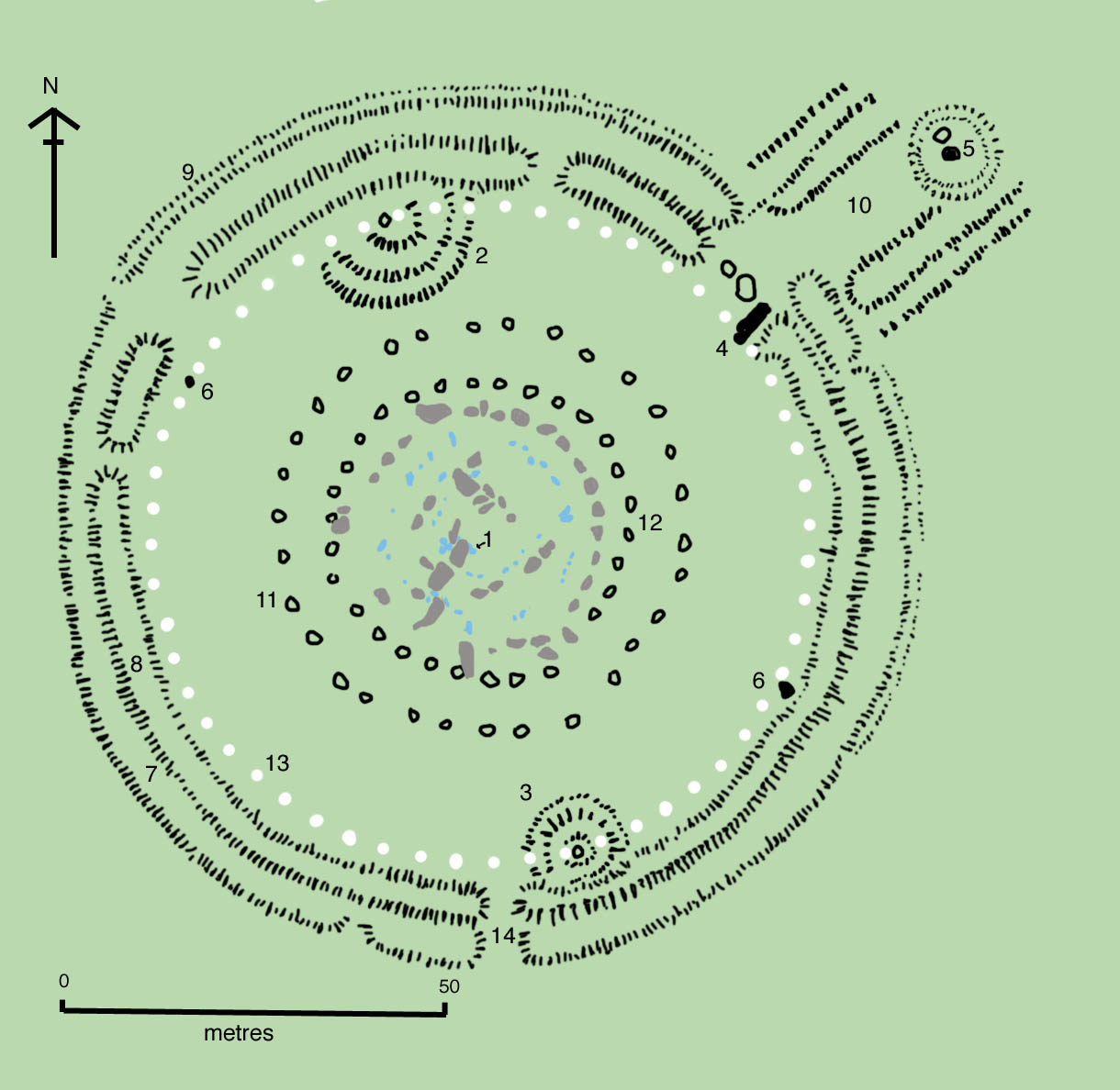
Drawn by en:User:Adamsan from sources:
- Cleal, Walker, & Montague, Stonehenge in its Landscape (London, English Heritage 1995)
- Pitts, M, Hengeworld (London, Arrow 2001)
Key to plan:
- 1 = The Altar Stone, a six ton monolith of green micaceous sandstone from Wales
- 2 = barrow without a burial
- 3 = "barrows" (without burials)
- 4 = the fallen Slaughter Stone, 4.9 metres long
- 5 = the Heel Stone
- 6 = two of originally four Station Stones
- 7 = ditch
- 8 = inner bank
- 9 = outer bank
- 10 = The Avenue, a parallel pair of ditches and banks leading 3 km to the River Avon
- 11 = ring of 30 pits called the Y Holes
- 12 = ring of 30 pits called the Z Holes
- 13 = circle of 56 pits, known as the Aubrey holes
- 14 = smaller southern entrance
The site as of AD 2004. The plan omits the trilithon lintels for clarity. Holes that no longer, or never, contained stones are shown as open circles and stones visible today are shown coloured, grey for sarsen and blue for the imported stone, mainly bluestone.

Odnośniki do pliku
Następujące strony odwołują się do tego pliku:
Metadane
Niniejszy plik zawiera dodatkowe informacje, prawdopodobnie dodane przez aparat cyfrowy lub skaner. Jeśli plik był modyfikowany, dane mogą być częściowo błędne.
| Orientacja | Normalna |
|---|---|
| rozdzielczosć w poziomie | 150 dpi |
| rozdzielczość w pionie | 150 dpi |
| Oprogramowanie | Adobe Photoshop 7.0 |
| Data i czas zmiany pliku | 17:42, 28 sie 2004 |
| Przestrzeń kolorów | 65535 |

