Imagem:Chernyakhov.PNG
Origem: Wikipédia, a enciclopédia livre.

Chernyakhov.PNG (777 × 471 pixel, tamanho do ficheiro: 25 KB, tipo MIME: image/png)
La bildo estas kopiita de wikipedia:en. La originala priskribo estas:
my own map, based on User:Dbachmann's blank map.
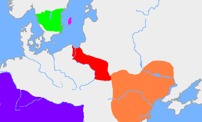
The extent of the Wielbark culture is based on Zbigniew Babik: "Najstarsza warstwa nazewnicza na ziemiach polskich" Cracow 2001.
The extent of the Chernyakhov culture is based on R. Wołągiewicz (1993), a map drawn by Lars Östlin, in Kaliff's Gothic Connections. Contacts between eastern Scandinavia and the southern Baltic coast 1000 BC – 500 AD (2001:29)

| date/time | username | edit summary |
|---|---|---|
| 22:03, 19 August 2005 | en:User:Wiglaf | |
| 20:55, 26 July 2005 | en:User:Wiglaf | |
| 13:04, 26 July 2005 | en:User:Wiglaf | |
| 12:57, 26 July 2005 | en:User:Wiglaf |
[edit] Historio de la dosiero
Legend: (cur) = this is the current file, (del) = delete this old version, (rev) = revert to this old version.
Click on date to download the file or see the image uploaded on that date.
- (del) (cur) 12:57, 26 July 2005 . . en:User:Wiglaf Wiglaf ( en:User_talk:Wiglaf Talk) . . 777x471 (25688 bytes)
Ligações
As seguintes páginas apontam para este ficheiro:

