صورة:Algeria-Annaba.png
من ويكيبيديا، الموسوعة الحرة

No higher resolution available.
Algeria-Annaba.png (200 × 195 pixel, file size: 5 KB, MIME type: image/png)
|
|
هذا الملف موجود في ويكيميديا كومنز، ويمكن استخدامه في مشاريع ويكيميديا الأخرى. لرؤية هذا الملف في ويكيميديا كومنز اتبع هذا الرابط. |
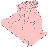
| Description |
Map of Algeria showing Annaba province. Deutsch: Lage in Algerien
English: Map of Algeria showing Annaba province
Español: Map of Algeria showing Annaba province
Français : Carte d'Algérie (Wilaya d'Annaba)
|
|---|---|
| Source |
Self-made, traced from public domain UN or CIA maps. |
| Date |
December 18 2004 |
| Author | |
| Permission |
Provide attribution, please. See below. |
| Other versions | See Image:Algeria provinces numbered.png for the numbered map of the provinces. |

وصلات
الصفحات التالية تحتوي على وصلة لهذه الصورة:

