Talk:British national grid reference system
From Wikipedia, the free encyclopedia
Sequence of presentation: the article has a lot of good stuff in it, but to me at least (not an expert in datums and ellipsoids) the order doesn't seem right. The 'general' section discusses some very technical stuff about the coordinates and the underlying shape *before* the article has explained the system of grid letters and numbers. I'd think most readers would want to know how the system is used before reading about the technical details of the mapping. I won't edit the article because it's outside my area... Sangwine 20:28, 17 November 2006 (UTC)
This page is very good, but could someone make a similar one explaining the Australian grid reference system, or even just tell me which map units options to choose with a Magellan eXplorist 100 GPS to get the coordinate system to agree with a topographical map? Thankyou, Kester Ratcliff. (It would be very nice if you could email me if you know the answer: bh.santi@gmail.com thanks.)
This article should compare (or at least reference) other national and international grid systems. 18.26.0.18 22:14, 19 Feb 2005 (UTC)
Does Ordnance Survey hold the copyright on the British national grid reference system? Do I have to pay royalties if I include a grid reference in a publication? Edward 17:29, 2005 Mar 25 (UTC)
- Do I have to pay royalties to a book publisher if I reference a particular page, line and word of one of their books? Laurel Bush 10:38, 1 Apr 2005 (UTC).
-
-
- Reading those references, I think this is a somewhat different case. Westlaw are (rightly or wrongly) arguing that the added value of their numbering system turns the, otherwise public domain, federal judicial decisions into a copyrightable derivative work. And therefore that other publishers cannot publish reports of judicial decisions based on their works. They don't appear to be arguing that others cannot cite references to their numbering system in other documents. -- Chris j wood 10:39, 18 May 2005 (UTC)
-
- This is a popular myth, probably not helped by OS's aggressive protection of their IP more generally. Essentially the British National Grid is a particular specification of the Transverse Mercator projection , which was presented by Johann_Heinrich_Lambert some time in the in the 1770's and later updated by Gauß and Kruger in the C18th and early C20th respectively. As such any copyright on the projection is held with them an expired and has long expired (the degree to which each is a derivative work of the next is not in question here). The only original element in the BNG is the system of naming of grid squares. However, this was first set out by the OS in 1936, as stated in the article and is Crown copyright. Under the Copyrights Designs and Patents Act 1988, Crown copyright extends to 50 years from publication (unlike your or my work, which was extended to 70 years in the same Act) and so any claim OS may have had over this expired in 1986.
-
- As far as I'm aware, current case law supports OS' ownership, given in Ordnance Survey vs Younger and others (Ch 10 April 1995), in which Sir Jeremy Vinelott, sitting as a Judge of the High Court, ruled that 'OS copyright material includes the National Grid' and that "the OS retain the right to refuse to allow...[someone]...to use the National Grid", a right which was in that case taken up. The Anome, you may be able to look this case up in Westlaw ;) -- Aled.greenhalgh 14:09, 31 March 2006 (UTC)
Contents |
[edit] S, T, N, & H
Does anyone know what significance these letters have? I can guess South, North, and Highlands, but why T (or indeed O)?
- The South and North thing is just a coincidence. The first letters follow the same pattern as the 2nd. Eg look at square NS (west central Scotland). To the east is NT, to the north NN, with NO to the east of that, and NH above NN. It's just alphabetic. Grinner 08:33, May 18, 2005 (UTC)
]. John Wheater 08:49, 22 September 2006 (UTC)
[edit] and O?
Does anyone else find it slightly odd that the southwest corner of the O square happens to sit exactly on the coast? Check out the map centred on OV000000 here [5] and you'll see what I mean. Coincidence, or was the origin chosen to keep square O out of the picture? Presumably not, as the origin was set at 49°N 2°W, but it still seems strange....
- Adding to the strangeness, I beleive that two OS maps meet there two - there is no overlap at that point, and so there is a small square of North Yorkshire beach that is not on an OS-map or a recognised Grid Ref. What are they tring to hide?.......
- Grinner 16:14, Jun 10, 2005 (UTC)
[edit] I* is cross-reference to the Irish grid
Some databases, at the very least http://www.ofcom.org.uk/radio/ifi/rl/commer/ar/tech_parameters/?a=87101, turn an Irish national grid reference system square into a general square by preceeding the Irish square with I (note that irish references have only one letter at the beginning, so this works out to the same format).
I have also seen references that claim to lay in square CI and being somewhere in the channel islands, but all my searches simply say that there is no national grid covering the channel islands.
At least the I* bit should probably be worked into the main text, but I don't know quite where to do so.
Re: The I for the Irish Grid - DMA 8538.1, Par. 2-1.5.1 says to use I as the grid letter with the Irish Transvers Mercator Grid, as an exception to the Normal British Grid Reference System method of lettering.
[edit] 1940s Introduction to the National Grid
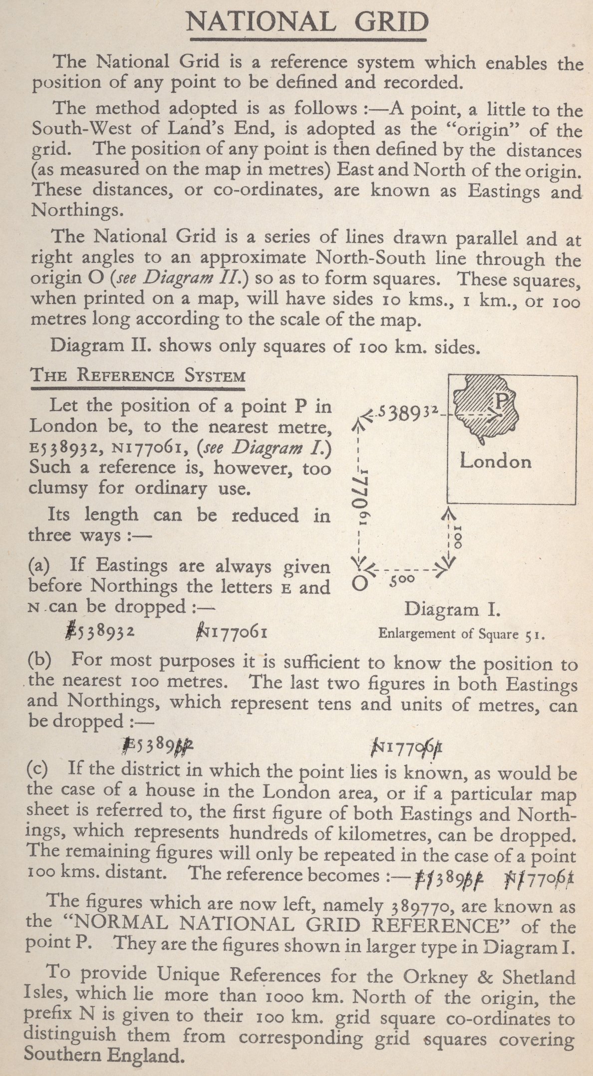
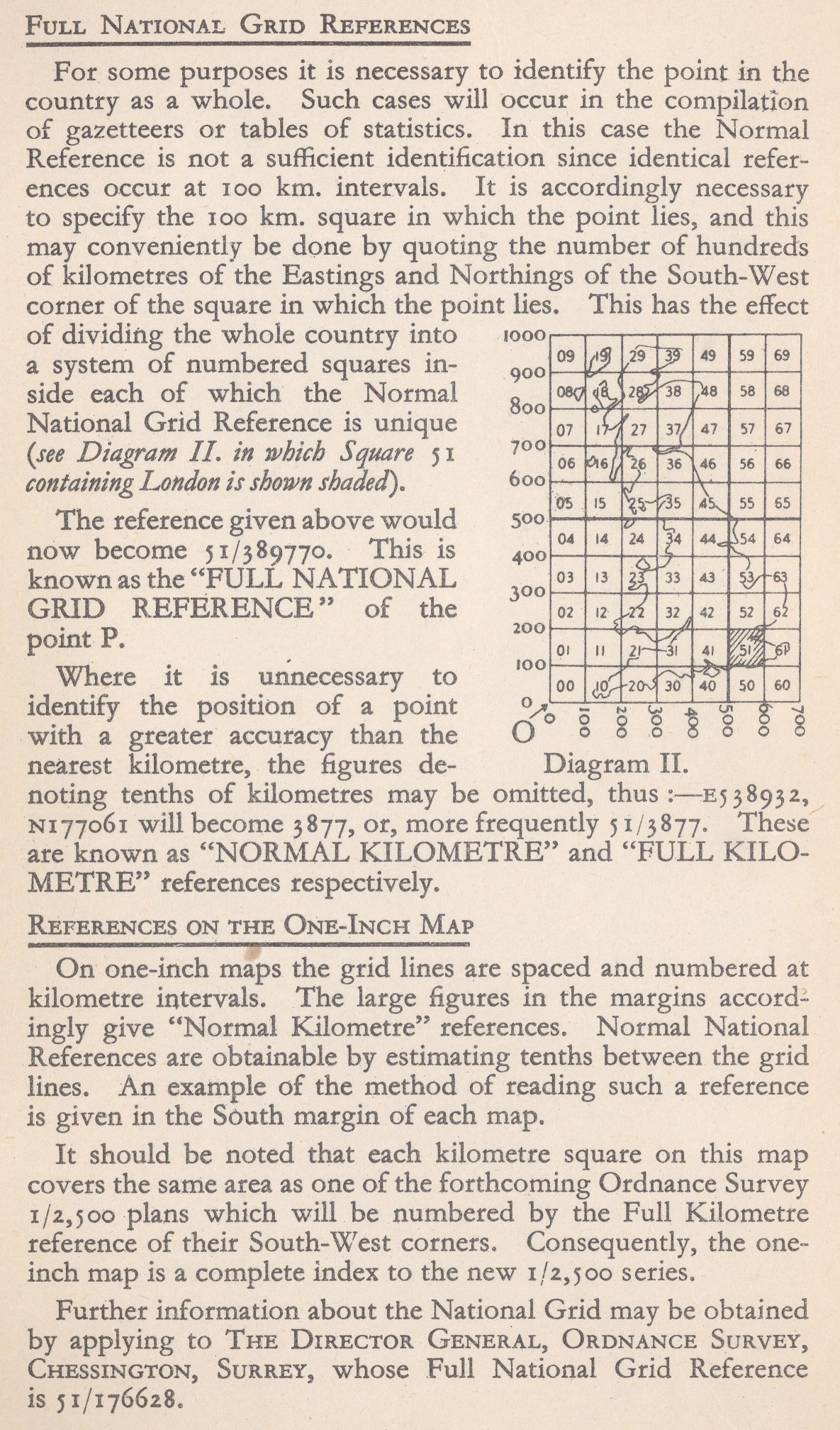
I've got a 1940s OS map (updated popular edition of Inverness). On its cover, in two parts, is a nice introduction to the National Grid.
Since crown copyright only lasts 50 years, this introduction (and two diagrams) is now out of copyright. Does someone want to have a stab at integrating it into the page? A scan of the cover is at http://gagravarr.org/misc/NationalGridIntro.jpg and http://gagravarr.org/misc/NationalGridRefs.jpg. --Gagravarr 18:37, 4 December 2006 (UTC)
- It's interesting to see that historically, national grid references were just numbers, of the form 51/176628 (which now resolves to TQ176628), could we add this somewhere as history? --Grand Edgemaster Talk 16:03, 1 January 2007 (UTC)

