Image:China-Inner-Mongolia.png
From Wikipedia, the free encyclopedia


No higher resolution available.
China-Inner-Mongolia.png (268 × 218 pixel, file size: 15 KB, MIME type: image/png)
| | This is a file from the Wikimedia Commons. The description on its description page there is shown below. |
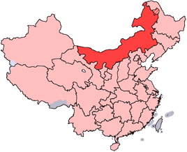
en: Location of Inner Mongolia Autonomous Region in the People's Republic of China. See Locator maps of province-level divisions of the People's Republic of China for more information. The striped area is nominally part of Inner Mongolia, but it is administered by Daxing'anling Prefecture of Heilongjiang Province.
zh: 内蒙古自治區在中華人民共和國的位置。另見Locator maps of province-level divisions of the People's Republic of China。加斜杠的地區由黑龍江省大興安嶺地區所管轄,僅在名義上為内蒙古的一部分。

File links
The following pages on the English Wikipedia link to this file (pages on other projects are not listed):
- Inner Mongolia
- Xanadu
- Suiyuan
- Greater Khingan
- Baotou
- Wikipedia:WikiProject Chinese provinces/Locator maps
- Wuhai
- Chifeng
- Hailar, Inner Mongolia
- Xing'an League
- Fengzhen
- Badain Jaran Desert
- Xilinhot
- Tongliao
- Ordos City
- Yin Mountains
- Hanggai
- Siziwang Banner
- Duolun
- Linhe
- Evenk Autonomous Banner
- Oroqin Autonomous Banner
- Qingcheng Park
- Solun (Inner Mongolia)
- Khalkhyn Gol
- Wulanhaote
- Pai-ling-miao
- Hongor
- Yakeshi
- Dongsheng
- Jiageda
- Erenhot
- Baotou Airport
- Chifeng Airport
- Hailar Dongshan Airport
- Hohhot Baita International Airport
- Manzhouli Airport
- Tongliao Airport
- Ulanhot Airport
- Wuhai Airport
- Xilinhot Airport
- Baynnur
- Template:InnerMongolia-geo-stub

