Bild:Azerbaijan districts numbered.png
aus Wikipedia, der freien Enzyklopädie

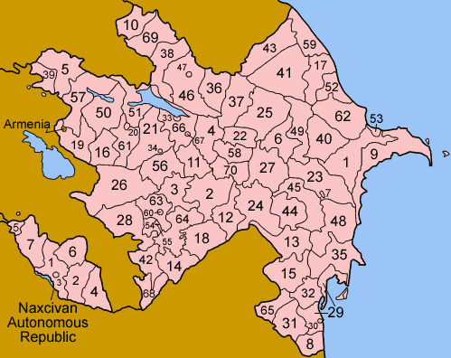
Azerbaijan_districts_numbered.png (750 × 595 Pixel, Dateigröße: 59 KB, MIME-Typ: image/png)
| | Diese Datei wird aus dem zentralen, mehrsprachigen Dateiarchiv Wikimedia Commons eingebunden. Die Quellen- und Lizenzangaben nach dem roten Trennstrich stammen von der Original-Beschreibungsseite der Datei. | |
| Description |
Map of the rayans and sahars (cities) of Azerbaijan, numbered in Azerbaijani alphabetical order. The former Nagorno-Karabakh Autonomous Oblast (and the self-proclained Nagorno-Karabakh Republic) is shown in pale green; two rayons, 26 (Kalbajar) and 56 (Tartar) are both partly in Nagorno-Karabakh, the rest in the green area are completely in Nagorno-Karabakh. The southern portion of 21 (Goranboy) is claimed by the Nagorno-Karabakh Republic, but it was not part of the Nagorno-Karabakh Autonomous Oblast, and is not reflected in this map. Some of the borders of the divisions of Nagorno-Karabakh are different from the official ones used by Azerbaijan; please see Image:Nagorno-Karabakh regions named english.png for a more detailed view of the area. List is in english, with Azerbaijani name following in parentheses if different from English.
The six rayons and one city of the Nakhichevan Autonomous Republic are listed and numbered separately. |
|---|---|
| Source |
Self-made, traced from public domain UN or CIA maps, referencing various Azerbaijani sources. |
| Date |
March 2006 |
| Author | |
| Permission |
Provide attribution, please. See below. |

Dateiverweise
Die folgenden Artikel benutzen diese Datei:

