Bild:Sweden counties.png
aus Wikipedia, der freien Enzyklopädie

Keine höhere Auflösung vorhanden.
Sweden_counties.png (240 × 512 Pixel, Dateigröße: 8 KB, MIME-Typ: image/png)
| | Diese Datei wird aus dem zentralen, mehrsprachigen Dateiarchiv Wikimedia Commons eingebunden. Die Quellen- und Lizenzangaben nach dem roten Trennstrich stammen von der Original-Beschreibungsseite der Datei. | |
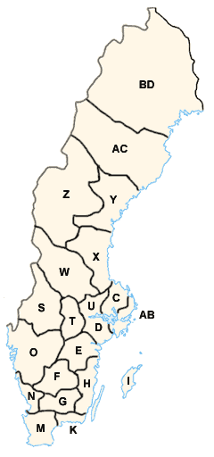
English: Sweden Counties/Län with partial ISO 3166-2 coding
Svenska: Sveriges län med kod ISO 3166-2
made by: User:Mic see Users Talk:Swedish Maps
first upload: Apr 15 2004
- Stockholm County (AB)
- Uppsala County (C)
- Södermanland County (D)
- Östergötland County (E)
- Jönköping County (F)
- Kronoberg County (G)
- Kalmar County (H)
- Gotland County (I)
- Blekinge County (K)
- Skåne County (M)
- Halland County (N)
- Västra Götaland County (O)
- Värmland County (S)
- Örebro County (T)
- Västmanland County (U)
- Dalarna County (W)
- Gävleborg County (X)
- Västernorrland County (Y)
- Jämtland County (Z)
- Västerbotten County (AC)
- Norrbotten County (BD)

 |
This map image should be recreated using vector graphics as an SVG file. This has several advantages; see Commons:Images for cleanup for more information. If an SVG form of this image is already available, please upload it. After uploading an SVG, replace this template with template {{SupersededSVG|new image name.svg}} in this image. |
|
Català | Česky | Dansk | Deutsch | English | Esperanto | Español | Français | Italiano | 日本語 | 한국어 | Nederlands | Polski | Português | Русский | العربية | 正體中文 | +/- |
|
Dateiverweise
Die folgenden Artikel benutzen diese Datei:

