Image:Eg-map.gif
From Wikipedia, the free encyclopedia

Eg-map.gif (342 × 367 pixel, file size: 13 KB, MIME type: image/gif)
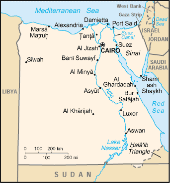
Map of Egypt from CIA World Factbook.
|
This image is a map or flag taken and/or modified from the Central Intelligence Agency's World Factbook. Under United States copyright law, all information and images from the World Factbook are in the public domain |
[edit] Licensing
I, the creator of this work, hereby release it into the public domain. This applies worldwide.
In case this is not legally possible,
I grant any entity the right to use this work for any purpose, without any conditions, unless such conditions are required by law.
File history
Legend: (cur) = this is the current file, (del) = delete
this old version, (rev) = revert to this old version.
Click on date to download the file or see the image uploaded on that date.
- (del) (cur) 20:31, 11 March 2007 . . Algocu (Talk | contribs) . . 342×367 (12,802 bytes) (Map of Egypt from [http://www.lib.utexas.edu/maps/cia03/egypt_sm03.gif CIA World Factbook]. {{PD-USGov-CIA-WF}} == Licensing == {{PD-self}} )
- Edit this file using an external application
See the setup instructions for more information.

