Talk:Herat
From Wikipedia, the free encyclopedia

Contents |
[edit] Map? and Ethnic Populations
-
-
- Were the original inhabitants ArIans or ArYans? As the former is asserted between two paragraphs talking about 500 BC and the 4th century Alexander the Great, I'd be very surprised if it were true, unless there are time-travelling Christian missionaries involved. So I'm guessing they were either Aryan or else the reference needs to be moved to a later spot in the chronology. -- Paul Drye
-
-
-
-
- Just thought that a gallery would better serve this article.--Zereshk 06:22, 17 July 2006 (UTC)
-
-
-
-
-
-
- I go to Herat at least 3 or 4 times every year. From my observation...Tajiks (approximately half Shia and half Sunni) and Pashtuns (mostly originating from Kandahar area) appear as 50%/50%. Most people in the city speak Herati (localized Persian language). In other words, Herati is the official language of the city. Pashto is also spoken among some of the Pashtuns, although most Pashtuns rather speak Herati. This confuses the westerners, assuming all those that speak Herati are Tajiks. Anyone who is Afghan and familiar with Herat will tell you that Pashtuns make up the second largest population. User:NisarKand November 11, 2006
-
-
-
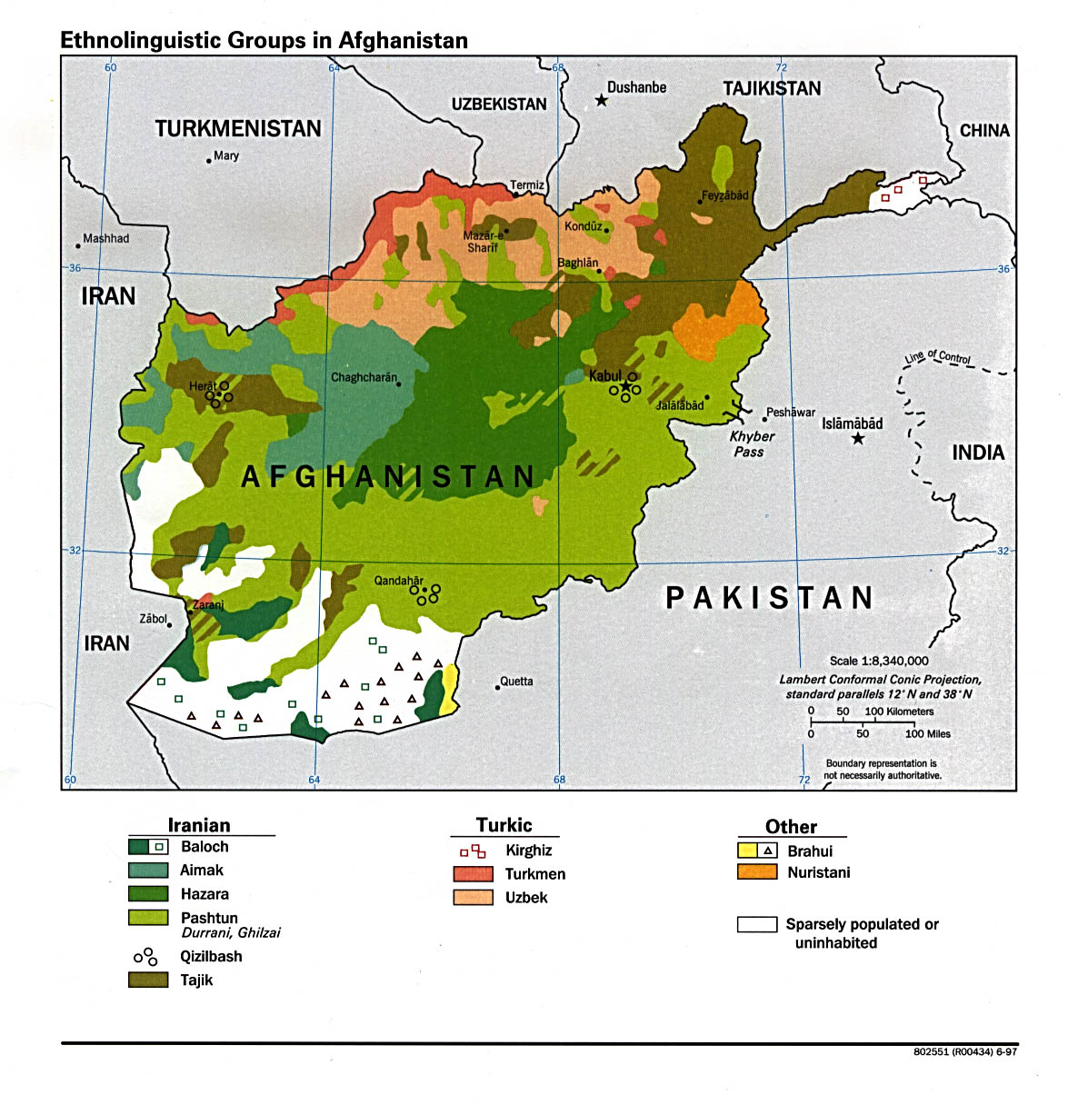
What map? The map of ethnic populations in Afghanistan with the main article? The scale is not sufficient for the municipality, if that is the map you think is used. Why not put this on the talk page for the article and discussion instead, or ask for a reference? KP Botany 21:51, 11 November 2006 (UTC)
- User NisarKand is claiming that "Pashtuns are the second largest ethnic group in Herat", and he have this map as a reference (see here). Beside that fact that no other source actually mentiones the second largest group in Herat (who could be Pashtuns, but also Hazaras or Turkmen), the a map can never be a proof for such a claim, because it does not show the number of speakers but only the geographical range of a certain language.
- There is no need to discuss this. It is a wrong source, and the claim has no base. NisarKand should discuss the issue before editing the article.
- Tājik 21:57, 11 November 2006 (UTC)
-
- You are not providing any data or sources that refute what NisarKand has backed up with the data he has provided, you simply say "there is no need to discuss this. It is a wrong source, and the claim has no base." You do not even say what is correct. Nothing, not what is right, not how or why it's wrong, simply that it is wrong. This is not an argument against the data, but simply your pushing your POV.
-
- Herat is an important world city, so it would be useful to research the underlying statistics and add them to the article--maybe Human Rights Watch has the data, or researchers at UNOmaha (theirs may even be on-line), or researchers at the American University of Afghanistan may be able to answer questions about the current demographics of Herat. Until then, NisarKand has bothered to provide a reputable source, and you have not provided a source contradicting it, or alternative information, but have merely provided your point of view that the source and NisarKand are wrong.
-
- Statistical data can be validly presented in graphs of all sorts, including maps. This map presents the information within the limits of its scale that metropolitan Herat is a city with two major ethnolinguistic groups.
-
- The article still needs a lot more work to be current and useful, rather than an edit war. KP Botany 00:23, 12 November 2006 (UTC)
-
-
- KP Botany, the problem with YOU is that you stubbornly and blindly support all the nonsense propagated by NisarKand. You did this in the article Afghanistan, and you are doing it here.
- A map is NEVER a source, because it does not provide numbers. I could also say that "Chinese and Swahili are the thrid and fourth numerous languages in Herat" ... Will you be able to disprove this?!
- It's not my job to find sources for NisarKand's (and your) nonsense ... YOU have to provide realiable sources BEFORE you edit the article and put nationalistic POV in it (and NisarKand is MOST DEFFINITLY a Pashtun nationalist ... he is neither an expert on Afghanistan, nor a scholar!).
- He should have provided a better map, for example this one: [1] This one includes NUMBERS and it clearly states that Tajiks are the majority in both Herat and Kabul. In Herat, Tajiks are 85% of the population, Pashtuns being only 10% ... There is absolutely no reason to include the number of Pashtuns into the article - and especially not in the intro! There are more Tajiks in Kandahar than Pashtuns in Herat or Ghazni! In a previous comment NisarKand stated that from his own "observation...Tajiks (approximately half Shia and half Sunni) and Pashtuns (mostly originating from Kandahar area) appear as 50%/50%". And YOU even blindly support this nationalistic nonsense ... With all due respect, you do not seem to be neutral, either ...
- PLEASE stop YOUR OWN POV-push ...
- Tājik 10:49, 12 November 2006 (UTC)
- This map you provide is not reliable either, because anyone can make a map nowadays with his numbers on it. How do you know these numbers are verified? As far as I know, adn as I mentioned earlier I am from Herat and so are all my ancestors, and we are Tajiks but NisarKand is right if he says that Pashtuns are the second largest group in Herat. But almost everyone in Herat, whether they are Tajik, Pashtun, Turkman, or any other group, speaks Herati dialect of Persian.IdrisModarres 18:53, 22 February 2007 (UTC)
- By the way User Tajik you call yourself Tajik and Ghazilbash at the same time. And as far as I know Ghazilbash's are not Tajiks but Turkish in origin. IdrisModarres 18:53, 22 February 2007 (UTC)
-
To be honost, I'm really not in the mood to argue with anyone over the ethnic population of Herat or any other city of Afghanistan. If you guys want to add that the entire Afghanistan's population is Tajiks...you may go ahead and write this everywhere. You may also state that Kandahar is 100% Tajiks, like if this gonna change anything. I know the fact that User:Tajik is Qizibash or whatever you spell it...and this group of people are the least in Afghanistan. I don't even think they make 1% of Afghanistan's population. It is not my duty to come up with the exact number of ethnic people living in each city. As an Afghan and a proud Pashtun...I explain to westerners that since majority of the people speaking Dari, Farsi, Herati, Persian or whatever you call that language....this does not mean all of those are ethnic Tajiks. The best example is USA again....majority of people in USA speak Enlgish but that does not mean they are ethnic English people. You have people from every ethnic of the world living in USA and all speaking English. This is the case in Afghanistan.
Finally, when Emperor Babur stated in his 1525 AD memoires about calling Tajiks "Sarts"....Perhaps he meant to call them "Rats". User:NisarKand November 13, 2006
User:Tajik goes around searching in garbage to find anything that mistakenly showes higher population of Tajiks in Afghanistan...and uses that falsely made information as evidence for his argument. This uneducated User:Tajik is clearly admitting to everyone here that his map from www.magix-photos.com Linkis the official estimate of Afghanistan's ethnic population. This User:Tajik assumes everyone in the world trust his trash that he finds online and expects us to believe his garbage. At the same time, this uneducated User:Tajik is strictly opposed to the map I provided from The University of Texas in Austin Link, which is a well known and most trusted University source. Even a non-talking donkey would turn face away from User:Tajik after learning of his nonsense and false information. User:Tajik is frustrated at Pashtuns for God knows why. I am not going to waste time with this uneducated User:Tajik any more, as I have much better things to do. We Pashtuns, with no doubts, have a very long history of ruling the region of Afghanistan. We successfully defeated Persians, Shias, British, Moghuls, Hindus, Russians and Tajiks. The Taliban were in fact Pashtuns and defeated the Tajiks after they assassinated Ahmad Shah Massoud on September 9, 2001. This is history and has nothing to do with my own nationalistic views. Iran, on the other hand, was badly defeated by Saddam Hussien in 1980s...and Iran does not have any history of winning any war. I am not against Iran in anyway by saying this...I am showing that I know more about history, which obviously makes me smart. Everybody is nationalistic in the world...this is nothing new...I would like User:Tajik to clearly say in here if he is nationalistic or not. Either he is or he is not...and nothing else. User:NisarKand November 13, 2006
This uneducated User:Tajik even goes to Pashtun people article and purposly removes the following information from there...Though no official sensus has ever been made in Afghanistan, an estimated 60 to 65% of all the people in Afghanistan speak Pashto Link. This uneducated User:Tajik does not believe anything or any source that showes higher number of Pashtuns or higher number of Pashto speakers in Afghanistan, meaning he or she has a serious ethnical problem with Pashtuns.
As I go to Kabul or other cities in Afghanistan...I see clowns posted many pictures or portraits of a dead Ahmad Shah Massoud everywhere...I ask my self why these clowns posting pictures of a dead person instead of the President of Afghanistan or even the vise President. This is what they call the work of silly clowns because these clowns are trying to make it appear as if Tajiks rule the country. Also, this is the precise reason why Taliban and others are regrouping. User:NisarKand November 13, 2006
[edit] Geography part was copied and pasted from another source and it is too long:
Please put it in other words and make it shorter:
[edit] Geography
The city of Herat lies in 34° 20' 30" N., and 62° 11' o" E., at an altitude of 2500 ft. above sea-level. Estimated pop. about io,000. It is a city of great interest historically, geographically, politically and strategically, but in modern days it has quite lost its ancient commercial importance. From this central point great lines of communication radiate in all directions to Russian, British, Persian and Afghan. territory. Sixty-six miles to the north lies the terminus of the Russian railway system; to the south-east is Kandahar (360 m.) and about 70 m. beyond that, New Chaman, the terminus of the British railway system. Southward lies Seistan (200 m.), and eastward Kabul (550 m.); while on the west four routes lead into Persia by Turbet to Meshed (215 m.), and by Birjend to Kerman (400 m.), to Yezd (500 m.), or to Isfahan (boo m.). The city forms a quadrangle of nearly i m. square (more accurately about 1600 yds. by r Soo yds.); on the western, southern and eastern faces the line of defence is almost straight, the only projecting points being the gateways, but on the northern face the contour is broken by a double outwork, consisting of the Ark or citadel, which is built of sundried brick on a high artificial mound within the enceinte, and a lower work at its foot, called the Ark-i-nao, or " new citadel," which extends ioo yds. beyond the line of the city wall. That which distinguishes Herat from all other Oriental cities, and at the same time constitutes its main defence, is the stupendous character of the earthwork upon which the city wall is built. This earthwork averages 250 ft. in width at the base and about 50 ft. in height, and as it is crowned by a wall 25 ft. high and 14 ft. thick at the base, supported by about r so semicircular towers, and is further protected by a ditch 45 ft. in width and 16 in depth, it presents an appearance of imposing strength. When the royal engineers of the Russo-Afghan Boundary Commission entered Herat in 1885 they found its defences in various stages of disrepair. The gigantic rampart was unflanked, and the covered ways in the face of it subject to enfilade from end to end. The ditch was choked, the gates were unprotected; the tumbled mass of irregular mud buildings which constituted the city clung tightly to the walls; there were no gun emplacements. Outside, matters were almost worse than inside. To the north of the walls the site of old Herat was indicated by a vast mass of debris - mounds of bricks and pottery intersected by a network of shallow trenches, where the only semblance of a protective wall was the irregular line of the Tal-i-Bangi. South of the city was a vast area filled in with the graveyards of centuries. Here the trenches dug by the Persians during the last siege were still in a fair state of preservation; they were within a stone's-throw of the walls. Round about the city on all sides were similar opportunities for close approach; even the villages stretched out long irregular streets towards the city gates. To the north-west, beyond the Tal-i-Bangi, the magnificent outlines of the Mosalla filled a wide space with the glorious curves of dome and gateway and the stately grace of tapering minars, but the impressive beauty of this, by far the finest architectural structure in all Afghanistan, could not be permitted to weigh against the fact that the position occupied by this pile of solid buildings was fatal to the interests of effective defence. By the end of August 1885, when a political crisis had supervened between Great Britain and Russia, under the orders of the Amir the Mosalla was destroyed; but four minars standing at the corners of the wide plinth still remain to attest to the glorious proportions of the ancient structure, and to exhibit samples of that decorative tilework, which for intricate beauty of design and exquisite taste in the blending of colour still appeals to the memory as unique. At the same time the ancient graveyards round the city were swept smooth and levelled; obstructions were demolished, outworks constructed, and the defences generally renovated. Whether or no the strength of this bulwark of North-Western Afghanistan should ever be practically tested, the general result of the most recent in vestigations into the value of Herat as a strategic centre has been largely to modify the once widely-accepted view that the key to India lies within it. Abdur Rahman and his successor Habibullah steadfastly refused the offer of British engineers to strengthen its defences; and though the Afghans themselves have occasionally undertaken repairs, it is doubtful whether the old walls of Herat are maintained in a state of efficiency.
The exact position of Herat, with reference to the Russian station of Kushk (now the terminus of a branch railway from Merv), is as follows: From Herat, a gentle ascent northwards for 3 m. reaches to the foot of the Koh-i-Mulla Khwaja, crossing the Jui Nao or " new " canal, which here divides the gravelcovered foot hills from the alluvial flats of the Hari Rud plain. The crest of the outer ridges of this subsidiary range is about 700 ft. above the city, at a distance of 4 m. from it. For 28 m. farther the road winds first amongst the broken ridges of the Koh-i-Mulla Khwaja, then over the intervening dasht into the southern spurs of the Paropamisus to the Ardewan pass. This is the highest point it attains, and it has risen about 21 5 0 ft. from Herat. From the pass it drops over the gradually decreasing grades of a wide sweep of Chol (which here happens to be locally free from the intersecting network of narrow ravines which is generally a distinguishing feature of Turkestan loess formations) for a distance of 35 m. into the Russian railway station, falling some 2700 ft. from the crest of the Paropamisus. To the south the road from Herat to India through Kandahar lies across an open plain, which presents no great engineering difficulties, but is of a somewhat waterless and barren character. The city possesses five gates, two on the northern face, the Kutab-chak near the north-east angle of the wall, and the Malik at the re-entering angle of the Ark-i-nao; and three others in the centres of the remaining faces, the Irak gate on the west, the Kandahar gate on the south and the Kushk gate on the east face. Four streets called the Chahar-sick, running from the centre of each face, meet in the centre of the town in a small domed quadrangle. The principal street runs from the south or Kandahar gate to the market in front of the citadel, and is covered in with a vaulted roof through its entire length, the shops and buildings of this bazaar being much superior to those of the other streets, and the merchants' caravanserais, several of which are spacious and well built, all opening out on this great thoroughfare. Near the central quadrangle of the city is a vast reservoir of water, the dome of which is of bold and excellent proportions. The only other public building of any consequence in Herat is the great mosque or Mesjid-i-Juma, which comprises an area of Boo yds. square, and must have been a most magnificent structure. It was erected towards the close of the 15th century, during the reign of Shah Sultan Hussein of the family of Timur, and is said when perfect to have been 465 ft. long by 275 ft. wide, to have had 4 08 cupolas,130 windows, 444 pillars and 6 entrances, and to have been adorned in the most magnificent manner with gilding, carving, precious mosaics and other elaborate and costly embellishments. Now, however, it is falling rapidly into ruin, the ever-changing provincial governors who administer Herat having neither the means nor the inclination to undertake the necessary repairs. Neither the palace of the Charbagh within the city wall, which was the residence of the British mission in 1840-1841, nor the royal quarters in the citadel deserve any special notice. At the present day, with the exception of the Chahar-sick, where there is always a certain amount of traffic, and where the great diversity of race and costume imparts much liveliness to the scene, Herat presents a very melancholy and desolate appearance. The mud houses in rear of the bazaars are for the most part uninhabited and in ruins, and even the burnt brick buildings are becoming everywhere dilapidated. The city is also one of the filthiest in the East, as there are no means of drainage or sewerage, and garbage of every description lies in heaps in the open streets.
Along the slopes of the northern hills there is a space of some 4 m. in length by 3 m. in breadth, the surface of the plain, strewn over its whole extent with pieces of pottery and crumbling bricks, and also broken here and there by earthen mounds and ruined walls, the debris of palatial structures which at one time were the glory and wonder of the East. Of these structures indeed some have survived to the present day in a sufficiently perfect state to bear witness to the grandeur and beauty of the old architecture of Herat. Such was the mosque of the Mosalla before its destruction. Scarcely inferior in beauty of design and execution, though of more moderate dimensions, is the tomb of the saint Abdullah Ansari, in the same neighbourhood. This building, which was erected by Shah Rukh Mirza, the grandson of Timur, over Soo years ago, contains some exquisite specimens of sculpture in the best style of Oriental art. Adjoining the tomb also are numerous marble mausoleums, the sepulchres of princes of the house of Timur; and especially deserving of notice is a royal building tastefully decorated by an Italian artist named Geraldi, who was in the service of Shah Abbas the Great. The locality, which is further enlivened by gardens and running streams, is named Gazir-gah, and is a favourite resort of the Heratis. It is held indeed in high veneration by all classes, and the famous Dost Mahommed Khan is himself buried at the foot of the tomb of the saint. Two other royal palaces named respectively Bagh-i-Shah and Takht-i-Sefer, are situated on the same rising ground somewhat farther to the west. The buildings are now in ruins, but the view from the pavilions, shaded by splendid plane trees on the terraced gardens formed on the slope of the mountain, is said to be very beautiful.
The population of Herat and the neighbourhood is of a very mixed character. The original inhabitants of Ariana were no doubt of the Aryan family, and immediately cognate with the Persian race, but they were probably intermixed at a very early period with the Sacae and Massagetae, who seem to have held the mountains from Kabul to Herat from the first dawn of history, and to whom must be ascribed - rather than to an infusion of Turco-Tartaric blood introduced by the armies of Jenghiz and Timur - the peculiar broad features and flattish countenance which distinguish the inhabitants of Herat, Seistan and the eastern provinces of Persia from their countrymen farther to the west. Under the government of Herat, however, there are a very large number of tribes, ruled over by separate and semi-independent chiefs, and belonging probably to different nationalities. The principal group of tribes is called the ChaharAimak, or " four races," the constituent parts of which, however, are variously stated by different authorities both as to strength and nomenclature. The Heratis are an agricultural race, and are not nearly so warlike as the Pathans from the neighbourhood of Kabul or Kandahar.
The long narrow valley of the Hari Rud, starting from the western slopes of the Koh-i-Baba, extends almost due west for 300 m. before it takes its great northern bend at Kuhsan, and passes northwards through the broken ridges of the Siah Bubuk (the western extremity of the range which we now call Paropamisus) towards Sarakhs. For the greater part of its length it drains the southern slopes only of the Paropamisus and the northern slopes of a parallel range called Koh-i-Safed. The Paropamisus forms the southern face of the Turkestan plateau, which contains the sources of the Murghab river; the northern face of the same plateau is defined by the Band-i-Turkestan. On the south of the plateau we find a similar succession of narrow valleys dividing parallel flexures, or anticlinals, formed under similar geological conditions to those which appear to be universally applicable to the Himalaya, the Hindu Kush, and the Indus frontier mountain systems. From one of these long lateral valleys the Hari Rud receives its principal tributary, which joins the main river below Obeh, 180 m. from its source; and it is this tributary (separated from the Hari Rud by the narrow ridges of the Koh-i-Safed and Band-iBaian) that offers the high road from Herat to Kabul, and not the Hari Rud itself. From its source to Obeh the Hari Rud is a valley of sandy desolation. There are no glaciers near its sources, although they must have existed there in geologically recent times, but masses of melting snow annually give rise to floods, which rush through the midst of the valley in a turbid red stream, frequently rendering the river impassable and cutting off the crazy brick bridges at Herat and Tirpul. It is impossible, whilst watching the rolling, seething volume of flood-water which swirls westwards in April, to imagine the waste stretches of dry river-bed which in a few months' time (when every available drop of water is carried off for irrigation) will represent the Hari Rud. The soft shales or clays of the hills bounding the valley render these hills especially subject to the action of denudation, and the result, in rounded slopes and easily accessible crests, determines the nature of the easy tracks and passes which intersect them. At the same time, any excessive local rainfall is productive of difficulty and danger from the floods of liquid mud and loose boulders which sweep like an avalanche down the hill sides. The intense cold which usually accompanies these sudden northern blizzards of Herat and Turkestan is a further source of danger.
From Obeh, 50 m. east of Herat, the cultivated portion of the valley commences, and it extends, with a width which varies from 8 to 16 m., to Kuhsan, 60 m. west of the city. But the great stretch of highly irrigated and valuable fruit-growing land, which appears to spread from the walls of Herat east and west as far as the eye can reach, and to sweep to the foot of the hills north and south with an endless array of vineyards and melon-beds, orchards and villages, varied with a brilliant patchwork of poppy growth brightening the width of green wheat-fields with splashes of scarlet and purple - all this is really comprised within a narrow area which does not extend beyond a ten-miles' radius from the city. The system of irrigation by which these agricultural results are attained is most elaborate. The despised Herati Tajik, in blue shirt and skull-cap, and with no instrument better than a three-cornered spade, is as skilled an agriculturist as is the Ghilzai engineer, but he cannot effect more than the limits of his water-supply will permit. He adopts the karez (or, Persian, kandt) system of underground irrigation, as does the Ghilzai, and brings every drop of water that he can find to the surface; but it cannot be said that he is more successful than the Ghilzai. It is the startling contrast of the Herati oasis with the vast expanse of comparative sterility that encloses it which has given such a fictitious value to the estimates of the material wealth of the valley of the Hari Rud.
The valley about Herat includes a flat alluvial plain which might, for some miles on any side except the north, be speedily reduced to an impassable swamp by means of flood-water from the surrounding canals. Three miles to the south of the city the river flows from east to west, spanned by the Pal-i-Malun, a bridge possessing grand proportions, but which was in 1885 in a state of grievous disrepair and practically useless. East and west stretches the long vista of the Hari Rud. Due north the hills called the Koh-i-Mulla Khwaja appear to be close and dominating, but the foot of these hills is really about 3 m. distant from the city. This northern line of barren, broken sandstone hills is geographically no part of the Paropamisus range, from which it is separated by a stretch of sandy upland about 20 m. in width, called the Dasht-i-Hamdamao, or Dasht-i-Ardewan, formed by the talus or drift of the higher mountains, which, washed down through centuries of denudation, now forms long sweeping spurs of gravel and sand, scantily clothed with wormwood scrub and almost destitute of water. Through this stretch of dasht the drainage from the main water-divide breaks downwards to the plains of Herat, where it is arrested and utilized for irrigation purposes. To the north-east of the city a very considerable valley has been formed between the Paropamisus and the subsidiary Koh-i-Mulla Khwaja range, called Korokh. Here there are one or two important villages and a well-known shrine marked by a group of pine trees which is unique in this part of Afghanistan. The valley leads to a group of passes across the Paropamisus into Turkestan, of which the Zirmast is perhaps the best known. The main water-divide between Herat and the Turkestan Chol (the loess district) has been called Paropamisus for want of any well-recognized general name. To the north of the Korokh valley it exhibits something of the formation of the Hindu Kush (of which it is apparently a geological extension), but as it passes westwards it becomes broke: Environs of Herat. into fragments by processes of denudation, until it is hardly recognizable as a distinct range at all. The direct passes across it from Herat (the Baba and the Ardewan) wind amongst masses of disintegrating sandstone for some miles on each side of the dividing watershed, but farther west the rounded knolls of the rain-washed downs may be crossed almost at any point without difficulty. The names applied to this debris of a once formidable mountain system are essentially local and hardly distinctive. Beyond this range the sand and clay loess formation spreads downwards like a tumbled sea, hiding within the folds of its many-crested hills the twisting course of the Kushk and its tributaries.
[edit] Picture replaced with an updated one.
This picture was replaced with an updated one, but I am placing it here in case we need it again in the future:

Parsiwan 21:09, 28 December 2006 (UTC)
-
-
- You should download the picture in the bigger size...by clicking on the top-left corner of the picture in its website. Its quality is better that way. If not then I will replace your picture with bigger size.--NisarKand 21:16, 28 December 2006 (UTC)
-
-
-
-
- Oh I see now! Thanks alot! I will upload a new version for all the ones I uploaded. Also for the one on the Kandahar article I uploaded last night. Thanks again for pointing that out! Parsiwan 21:23, 28 December 2006 (UTC)
-
-
-
-
-
-
-
- hey, this is my photo, so i can provide a larger version if needed. i have the negatives and a 3700x2500 scan if you want... bluuurgh 16:13, 30 December 2006 (UTC)
-
-
-
-
-
-
-
-
-
-
-
- Its a great picture, thanks alot for uploading it. But that picure is a little outdated. Now the Musallah Complex has roads around it with traffic, so I think a more updated picture is better. But thanks again for uploading that nice picture. Parsiwan 05:14, 3 January 2007 (UTC)
-
-
-
-
-
-
User Tajik states that Most of Herat is Parsiwan, who are Shiite. But as far as I know, and I myself is from Herat, there are only a small minority of Shiite in Herat, who do trading most of all. Most of the land owners of Herat are Sunnis. But as I wrote in the article today there are many Hazara who settle in Herat with the help of Iran and the governer.
[edit] Religion of Heratis
User Tajik states that Most of Herat is Parsiwan, who are Shiite. But as far as I know, and I myself am from Herat, there are only a small minority of Shiite in Herat, who do trading most of all. Most of the land owners of Herat are Sunnis. But as I wrote in the article today there are many Hazara who settle in Herat with the help of Iran and the governer.
- It's not my claim, but that of a scholar, and the source is attached to text. Personally, I do not know the exact percentage of Shias in Herat. But I do know that - compared to the rest of Afghanistan (except for Hazarajat) - the city of Herat has the largest concentration of Shias. So, as long as you do not have exact sources, please do not change the text. Tājik 15:45, 22 February 2007 (UTC)
-
-
- Tajik please do not remove my modifications. I did not remove your source that claims that almost all Herati's are Shiites. I just stated that it is wrong. This source of yours is from 1973. We know that in those times there were no exacts numbers about the population of all Afghanistan, let even Herat. And, as I stated, I am from Herat and my father is from Herat and so is my grandfather and so is my grand grandfather and so on, and I know a lot of Heratis, Shiites and Sunnis. And all of the Herati Shiites will agree with me on this that only in the center of the city live a Shiite minority, particularly in Bekr Abad. And most of the inhabitants and land owners are Sunnis. (I don't claim all of this because I am against Shiites, but only because I don't want people to read inaccurate facts about Herat.)
- And as far as the Hazara immigration is concerned, it's a true fact. You do not have to wait until a researcher has made a study of it and published the results before you can report about it. It is a fact, go look in Herat. All our mosques were Sunni mosques(if many Heratis were Shiite there would probably be more Shiite mosques outside the city center). Last year when I visited my beloved city I saw in one of the old mosques (actually a shrine) in Herat, Imam Shish Noor, all this Shiite prayers clay tablets in this mosque together with a lot of Iranian propaganda hanging at the walls. Well as far as I know this in this area there were no Shiites in the past. So how do you explain that? And why would I not be aloud to write about it to inform the people about it?
- Al thou I don't like personal attacks, but I begin to suspect that you are modifying this article just because you are a Shiite yourself. And you want to show that Herat is a Shiite city. So you go and dig through the sources and find one weak source that supports your claim and then you use that to spread what you want.
- Another point: If you manage to get me abandoned, then this proves that Wikipedia is a bad source of information because of people like you. I don't have time to continue this edit war for eternity. But it seems like you have the time. And you will probably push through your will anyway. IdrisModarres 21:03, 1 March 2007 (UTC)
-
-
-
- I also have a question: why are all famous Heratis Sunnis if the majority of Heratis are Shiites? Why are all historic landmarks in Herat build by Sunnis? Not all scholarly sources are comparable.
- And your source # ^ P. English, "Cities In The Middle East", e.d. L. Brown, Princeton University, USA 1973 is one of the least reliable sources, I believe. I couldn't find it anywhere in Holland University libraries. If it would be an authority on this subject I think there would be a copy of it somewhere in Holland. —The preceding unsigned comment was added by IdrisModarres (talk • contribs) 22:21, 1 March 2007 (UTC).
-
How reliable is Encyclopedia Iranica? What does Iranica says about Afghanistan about Parsiwans: (http://www.iranica.com/newsite/articles/v1f5/v1f5a040a.html) Fa@rs^wa@n. Language: Dar^. Of the basic Mediterranean sub-stock, about 600,000 live near the Afghan-Iranian border or in the districts of Herat, Qandaha@r, GÚazn^, and other southern and western towns. The term Fa@rs^wa@n also has the regional forms Pa@rs^wa@n and Pa@rs^ba@n. In religion they are Imamite Shi¿ite. In the literature they are often mistakenly referred to as Tajik. Bibliog: P. English, “The Pre-industrial City of Herat,” Cities in the Middle East, ed. L. Brown, Princeton, 1973. H. Baghban, The Content and Concept of Humor in Magadi Theater, PhD thesis, Indiana University (University Microfilms 77-10-977).
Couple of remarks: Qandahar and Ghazni are NOT near the Iranian border, nor are they near the west. SO how reliable is this source anyway???!!! This is an Encyclopedia. And an Encyclopedia is not always right about every subject.
- The articles says: "They lieve near the Afghan-Iranian border OR in Herat, Qandahar, and Ghazni". You certainly lack the ability to read and/or to understand. Encyclopaedia Iranica is a primary source and is authoritative. This is what scholars say about Iranica. Tājik 20:55, 2 March 2007 (UTC)
I have another question: if most of Heratis are Shiites then how come that at the last elections their representatives were not all elected to Wolesi Jirga & Provincial Council? Why did most of the Heratis choose Sunni's as their representatives? I can not believe it. If I am correct the first highest place in the Wolesi Jirga to be taken by a Shiite is the tenths place and he got only 1.8 % of all the votes; In the Provincial Council it is the second place and still this guy, called Najafi, got only 3.1 percent of all the votes. (http://www.results.jemb.org/province.asp?ProvinceID=24 )
Iranica may be an authority on Iran but it certainly is not on Afghanistan related subjects. There have been not any reliable researches about Afghan population for decades. So how can someone have exact numbers about the population of Afghanistan?
And for the Hazara immigration to Herat, look at all the tension there is the last years between Sunnis and Shiites in Herat. You act like you are an authority on Herat. I don't think you have ever been in Herat. Neither the one that wrote about the Parsiwans in Iranica.
And as the term Parsiwan: the Pashto speaking people in Afghanistan call every Persian speaker a Parsiwan, and some of them, in particularly the Taliban, accuse all the Farsi speakers of being Shiite. Due to this during the reign of the Taliban it was very hard for the Persian speaking majorities in Herat, and other parts of Afghanistan, because Taliban did not liked Shiites, and accused Tajiks of being Shiite and friends of Iran.
I don't know whether I ever will be able to convince you, but I will continue to correct your mistake. I am not an expert on all the other things you write about, but on Herat I know what I am talking about.IdrisModarres 00:07, 5 March 2007 (UTC)
- With all due respect: you have absolutely no knowledge of the subject. Your comments about Iranica (the standard reference work on Iranian and Islamic studies) and your odd theories about elections (and in this case, you probably assume that 100% of Herat's population participated in the elections) show this. You do not even know the difference between Islamic Republic Iran and the more general term Iran which is used for Iranian peoples, Iranian languages, Iranian plateau, etc.
- As long as you have no reliable sources, you should not change the article based on your own POV. Tājik 01:28, 5 March 2007 (UTC)


![[1]](http://www.magix-photos.com/mediapool04/22/DD/4B/10/D2/8D/11/D9/BE/75/69/B3/50/AB/06/3B/oma/10/44D9DE7018E411DA8733BDA2D527D07B.jpg)