
Imaj:The Earth seen from Apollo 17.jpg
Depi Wikipedya, ansiklopedi lib
Lajè kout zye sa a : 599 × 599 piksèl
Imaj pli gwo, pli fin (3 000 × 3 002 piksèl, lajè fichye a : 6,21 Mo, tip MIME li ye : image/jpeg)
| Description |
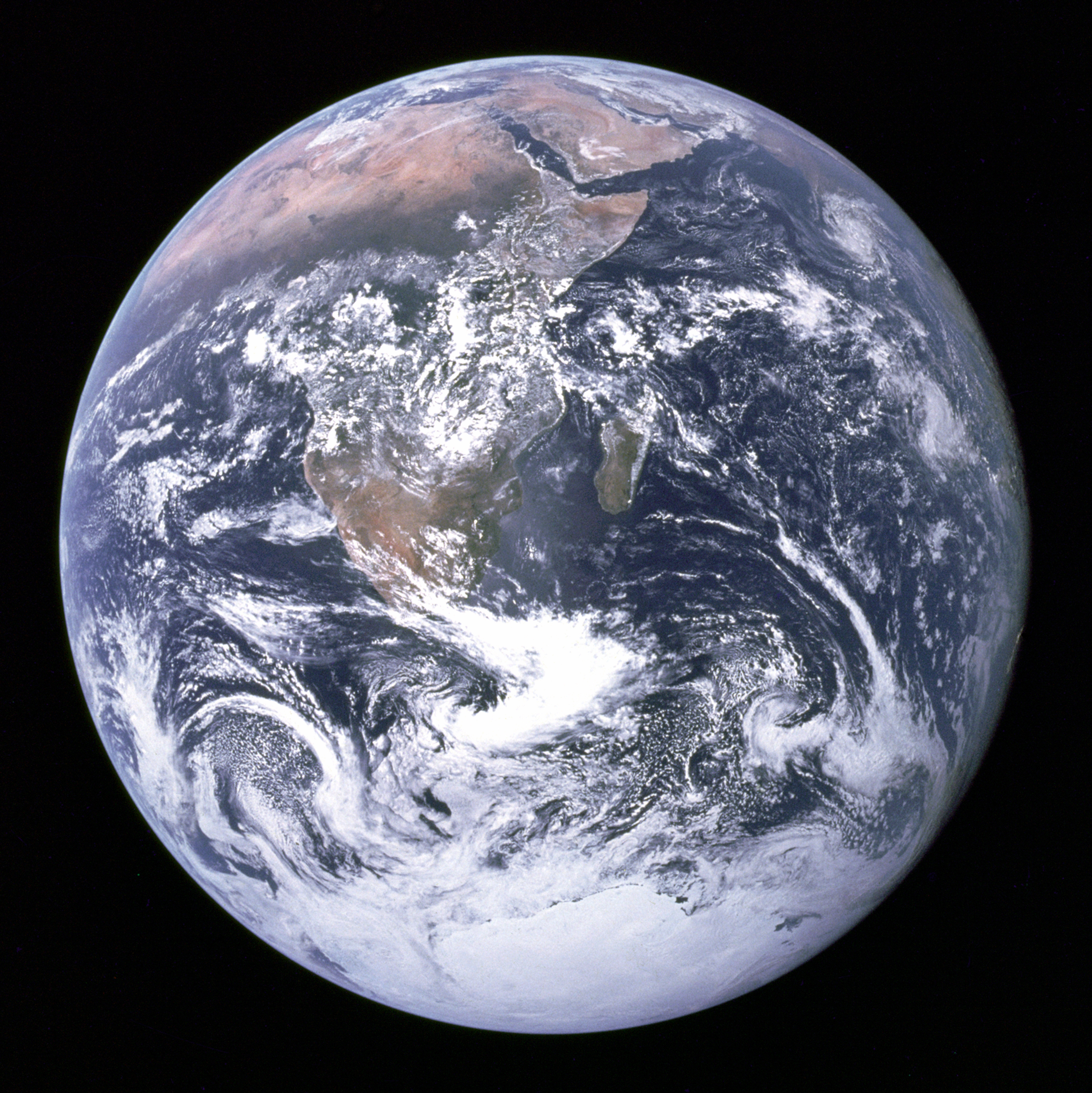
English: The Blue Marble: This photo is of Africa, Antarctica, and the Arabian Peninsula as taken en route to the Moon by Apollo 17's Harrison Schmitt or Ron Evans[1] on December 7, 1972. The flight marked the last time that humans left low Earth orbit and the first and only time a geologist, Harrison Schmitt, travelled to the moon.
N.B: This photo is upside-down; in the original photo the south pole is at the top. Deutsch: „Blue Marble“, die während des Fluges von Apollo 17 zum Mond am 7. Dezember 1972 entstandene Fotoaufnahme von der Erde (in der zur besseren Wiedererkennbarkeit um 180 Grad gedrehten Version).
Français : La bille bleue: Photo de l'Afrique, de l'Antarctique et de la péninsule Arabique prise en route pour la lune par Harrison Schmitt ou Ron Evans lors de la mission Apollo 17 le 7 décembre 1972. Ce vol a été le dernier à quitter l'orbite terrestre, et le seul au cours duquel un géologue, Harrison Schmitt, s'est rendu sur la lune.
N.B: Cette image est à l'envers: Sur l'image originale, le pôle sud est en haut. |
|||||
|---|---|---|---|---|---|---|
| Source |
This image is a low compression JPEG version of The Earth seen from Apollo 17.png, which itself was taken from NASA [2].
|
|||||
| Date |
December 7, 1972. |
|||||
| Author |
Image courtesy of Earth Sciences and Image Analysis Laboratory, NASA Johnson Space Center. File Name AS17-148-22727 |
|||||
| Permission (Reusing this image) |
|
|||||
| Other versions | This photo with white background is available at Image:The Earth seen from Apollo 17 trsp back.jpg |

| This image or video was catalogued by Johnson Space Center of the United States National Aeronautics and Space Administration (NASA) under Photo ID: AS17-148-22727. This tag does not indicate the copyright status of the attached work. A normal copyright tag is still required. See Commons:Licensing for more information. |
| This is a featured picture on Wikimedia Commons. We think it is one of the finest images on Commons; see its nomination. If you have an image of similar quality that can be published under a suitable copyright license, be sure to upload it, tag it, and nominate it. |
| This image was selected as a picture of the day for August 20, 2006. It was captioned as followed:
العربية: الأرض كما شوهدت من ابولو 17.
Cymraeg: Y Ddaear, delwedd oddiwrth Apollo 17.
Dansk: Jorden set fra Apollo 17
Deutsch: Blick auf die Erde von der Apollo 17.
Français : La Terre vue depuis Apollo 17.
Galego: The Blue Marble: Fotografía da Terra tomada, o 7 de decembro de 1972, pola tripulación do Apollo 17 na súa ruta cara a Lúa. Mostra África, a Antártida e a península Arábiga. Foi tomada a unha distancia de 45.000 km aproximadamente
Português: A Terra vista desde a Apollo 17.
Bân-lâm-gú: Tiàm Apollo 17-hō thài-kong pe-chûn téng-kôan, iōng thian-bûn-kiàⁿ khòaⁿ tē-kiû ê kéng-tì.
|
Istorik fichye a
Klike anlè yon dat epi yon lè pou fichye a jan li te ye nan moman sa a.
| Dat ak lè | Itilizatè | Grandè yo | Lajè fichye a | Komantè | |
|---|---|---|---|---|---|
| Kounye a | 31 jiyè 2005 à 02:25 | Tom | 3 000×3 002 | 6,21 Mo | larger image |
| 29 desanm 2004 à 22:41 | Ed g2s | 1 860×1 898 | 762 ko | {{PD-USGov-NASA}} |
Paj yo ki genyen imaj an
Paj ki ap swiv yo genyen imaj sa a :
Metadone
Dosye sa genyen enfòmasyon adisyonèl, petèt adisyone soti nan yon kamera dijital oubyen yon eskennè itilize pou kreye oubyen dijitalize li. Si dosye sa se yon modifikasyon, kèk detay ka pa menm avèk original la.
| Orientation | Normale |
|---|---|
| Résolution horizontale | 300 dpi |
| Résolution verticale | 300 dpi |
| Logiciel utilisé | Adobe Photoshop CS Windows |
| Date et heure de changement du fichier | 13 me 2005 à 13:09 |
| Espace colorimétrique | sRGB |

