
Image:Nauru map.jpg
From Wikipedia

Size of this preview: 484 × 600 pixels
Full resolution (994 × 1,232 pixel, file size: 128 KB, MIME type: image/jpeg)
| Description |
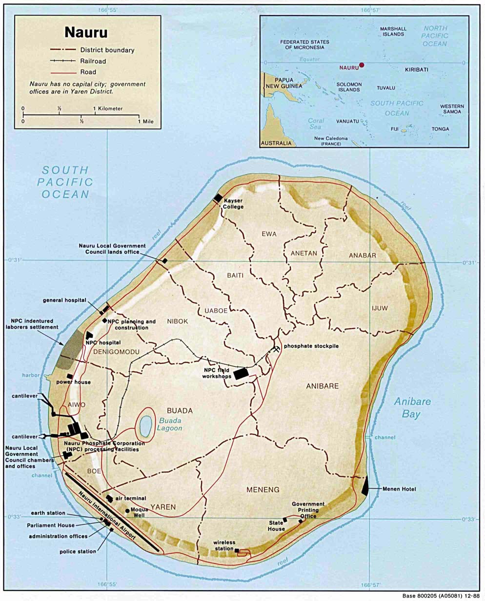
Small-label map of the island of Nauru (click image to enlarge for reading labels), northeast of Australia, north of the Solomon Islands and northwest of Fiji. The island is surrounded by a coral reef ring. |
|---|---|
| Source |
URL: http://www.lib.utexas.edu/maps/islands_oceans_poles/nauru.jpg (copy). |
| Date |
26-March-2005 |
| Author |
UT-Austin, uploaded by User:Jon Harald Søby |
| Permission (Reusing this image) |
see below |
| Other versions |
Same map with larger labels: Image:Nauru_map_bold.jpg (has larger labels of nearby areas, the oceans, and district names). |
<span id="field-otherversions" summary="{{urlencode:Same map with larger labels: Image:Nauru_map_bold.jpg (has larger labels of nearby areas, the oceans, and district names).
Also see: Nauru maps in Wikimedia's Atlas of Nauru.">
- Notes: The map shows some detailed contour areas near the shoreline.
[edit] Licensing
Note: This is not a copyright tag! Many images that use this tag are likely to be in the public domain, but many images, like for example images from WWII taken by members of the axis powers are not. Images must contain a valid copyright tag in addition to this one! For example:
or any other appropriate license tag. |
|
| This image is a copy of nauru.jpg, a map from the map collection of the Perry-Castañeda Library (PCL) of the University of Texas at Austin. According to the FAQs it might be in the public domain, but please provide additional proof for that. | |
 |
This map image should be recreated using vector graphics as an SVG file. This has several advantages; see Commons:Media for cleanup for more information. If an SVG form of this image is already available, please upload it. After uploading an SVG, replace this template with template {{Vector version available|new image name.svg}} in this image. |
|
العربية | Català | Česky | Dansk | Deutsch | English | Esperanto | Español | Français | 한국어 | Italiano | Magyar | Nederlands | 日本語 | Polski | Português | Română | Русский | Suomi | Svenska | Türkçe | Українська | Tiếng việt | 正體中文 | 简体中文 | +/- |
|
Map crated by the U.S. Central Intelligence Agency:
| This work is in the public domain in the United States because it is a work of the United States Federal Government under the terms of Title 17, Chapter 1, Section 105 of the US Code. See Copyright.
Note: This only applies to works of the Federal Government and not to the work of any individual U.S. state, territory, commonwealth, county, municipality, or any other subdivision. العربية | Български | Česky | Deutsch | English | Español | Français | Magyar | Italiano | 日本語 | 한국어 | Polski | Português | 简体中文 | 正體中文 | +/- |
 |
File history
Click on a date/time to view the file as it appeared at that time.
| Date/Time | User | Dimensions | File size | Comment | |
|---|---|---|---|---|---|
| current | 23:48, 26 March 2005 | Jon Harald Søby | 994×1,232 | 128 KB | From the English Wikipedia. {{PD-USGov}} |
Links
The following pages link to this file:

