Imagem:Bahrain-Sitrah.png
Origem: Wikipédia, a enciclopédia livre.

Resolução maior não disponível.
Bahrain-Sitrah.png (100 × 163 pixel, tamanho do ficheiro: 4 KB, tipo MIME: image/png)
| Description |
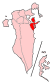
Map of Bahrain showing Sitrah municipality. The municipalities were dissolved in 2002 and replaced with governorates. English: Map of Bahrain showing Sitrah municipality
Português: A municipalidade de Sitrah
|
|---|---|
| Source |
Self-made, traced from public domain UN or CIA maps, with information from the Bahrain government. |
| Date |
December 18 2004 |
| Author | |
| Permission |
Provide attribution, please. See below. |
| Other versions | See Image:Bahrain municipalities numbered.png for the numbered map of the municipalities. |

Ligações
As seguintes páginas apontam para este ficheiro:

