Image:United States 1792-06-1795.png
From Wikipedia, the free encyclopedia

Size of this preview: 800 × 542 pixel
Image in higher resolution (1000 × 677 pixel, file size: 100 KB, MIME type: image/png)
| | This is a file from the Wikimedia Commons. The description on its description page there is shown below. |
[edit] Summary
| Description |
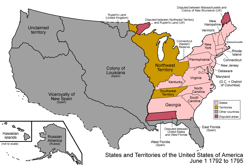
Map of the states and territories of the United States as it was from 1792 to 1795. On June 1 1792, four western counties were split off from Virginia and admitted as the state of Kentucky. Sometime in 1795, the territorial dispute with West Florida was resolved in the United States' favor. |
|---|---|
| Source | |
| Date | |
| Author |
Made by User:Golbez. |
| Permission |
Own work, attribution required (Multi-license with GFDL and Creative Commons CC-BY 2.5) |
|

| Territorial evolution maps of the United States |
| (template shows date of beginning of change yyyy-mm-dd) |
| 1789-03, 1789-08, 1790, 1791-03, 1791-09, 1792-03, 1792-06, 1795, 1796, 1798, 1800-07-04, 1800-07, 1802, 1803-03, 1803-04, 1804-03, 1804-10, 1805-01, 1805-07, 1809, 1810, 1812-04, 1812-05, 1812-06, 1812-12, 1816, 1817-03, 1817-12, 1818-10, 1818-12, 1819-03, 1819-12, 1820, 1821-07, 1821, 1822, 1824, 1828, 1834, 1836-03, 1836-06, 1836-07, 1837-01, 1837-03, 1838, 1842, 1845-03, 1845-12, 1846-06, 1846-12, 1848-02, 1848-05, 1848-08, 1849, 1850, 1853-03, 1853-12, 1854, 1858, 1859, 1860, 1861-01, 1861-02-04, 1861-02-28, 1861-03, 1861-08, 1862, 1863-02, 1863-03, 1863-06, 1864-05, 1864-10, 1865, 1866, 1867-01, 1867-03, 1867-10, 1868, 1876, 1884, 1889-11-02, 1889-11-08, 1889-11-11, 1890-05, 1890-07-03, 1890-07-10, 1896-01, 1896-05, 1898, 1907, 1912-01, 1912-02, 1912-08, 1959-01, 1959-08
|
[edit] Licensing
File links
The following pages on the English Wikipedia link to this file (pages on other projects are not listed):

