Image:United States 1858-1859.png
From Wikipedia, the free encyclopedia

Size of this preview: 800 × 542 pixel
Image in higher resolution (1000 × 677 pixel, file size: 103 KB, MIME type: image/png)
| | This is a file from the Wikimedia Commons. The description on its description page there is shown below. |
| Description |
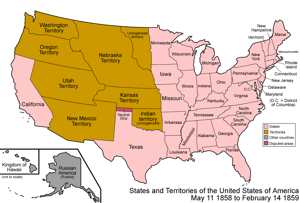
Map of the states and territories of the United States as it was from 1858 to 1859. On May 11 1858, part of Minnesota Territory was admitted as the state of Minnesota, the remainder becoming unorganized. On February 14 1859, part of Oregon Territory was admitted as the state of Oregon, the remainder joining on to Washington Territory. |
|---|---|
| Source | |
| Date | |
| Author |
Made by User:Golbez. |
| Permission |
Own work, attribution required (Multi-license with GFDL and Creative Commons CC-BY 2.5) |
|

| Territorial evolution maps of the United States |
| (template shows date of beginning of change yyyy-mm-dd) |
| 1789-03, 1789-08, 1790, 1791-03, 1791-09, 1792-03, 1792-06, 1795, 1796, 1798, 1800-07-04, 1800-07, 1802, 1803-03, 1803-04, 1804-03, 1804-10, 1805-01, 1805-07, 1809, 1810, 1812-04, 1812-05, 1812-06, 1812-12, 1816, 1817-03, 1817-12, 1818-10, 1818-12, 1819-03, 1819-12, 1820, 1821-07, 1821, 1822, 1824, 1828, 1834, 1836-03, 1836-06, 1836-07, 1837-01, 1837-03, 1838, 1842, 1845-03, 1845-12, 1846-06, 1846-12, 1848-02, 1848-05, 1848-08, 1849, 1850, 1853-03, 1853-12, 1854, 1858, 1859, 1860, 1861-01, 1861-02-04, 1861-02-28, 1861-03, 1861-08, 1862, 1863-02, 1863-03, 1863-06, 1864-05, 1864-10, 1865, 1866, 1867-01, 1867-03, 1867-10, 1868, 1876, 1884, 1889-11-02, 1889-11-08, 1889-11-11, 1890-05, 1890-07-03, 1890-07-10, 1896-01, 1896-05, 1898, 1907, 1912-01, 1912-02, 1912-08, 1959-01, 1959-08
|
File links
The following pages on the English Wikipedia link to this file (pages on other projects are not listed):

