Beeld:Deutschland Besatzungszonen 1945 1946.png
vanuit Wikipedia, die vrye ensiklopedie.

Size of this preview: 464 × 599 pixel
Image in higher resolution (500 × 646 pixel, file size: 20 KB, MIME type: image/png)
[edit] Beschreibung, Quelle und Lizenz
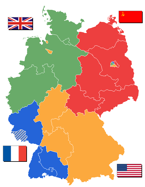
Einige Bundesländer sind erst 1946 entstanden. 1946 wurde das Saarland allerdings aus der französischen Besatzungszone ausgegliedert.
Flaggen aus Wikipedia.
Karte gezeichnet von User WikiNight
Nederlands: Geallieerde bezettingszones in Duitsland 1945/1946 met deelstaten
[edit] Lizenz

[edit] Image History
- 11:44, 31. Okt 2005 . . WikiNight (Diskussion) . . 500 x 646 (26694 Byte) (+Landkreis Lindau korr.)
- 13:27, 20. Sep 2005 . . WikiNight (Diskussion) . . 500 x 646 (26738 Byte) (Manche Bundesländer sind erst 1946 gebildet worden. 1946 aber auch das Saarland aus der fr.BZ rausgenommen. Bild selbst erstellt.)
 |
This map image should be recreated using vector graphics as an SVG file. This has several advantages; see Commons:Images for cleanup for more information. If an SVG form of this image is already available, please upload it. After uploading an SVG, replace this template with template {{SupersededSVG|new image name.svg}} in this image. |
|
Català | Česky | Dansk | Deutsch | English | Esperanto | Español | Français | Italiano | 日本語 | 한국어 | Nederlands | Polski | Português | Русский | العربية | 正體中文 | +/- |
|
Prentskakels
Die volgende bladsye gebruik hierdie prent:

