Geography of Belgium
From Wikipedia, the free encyclopedia
| Geography of Belgium | |
 |
|
| Continent | Europe |
| Region | Western Europe |
| Coordinates | |
| Area | Ranked 139th 33,990 km² 13,124 miles² 89% land 11% water |
| Coastline | 73.1 km (45 miles) |
| Borders | Total land borders: 1,482 km (859 miles) France 645 km, Germany 153 km, Luxembourg 150 km and Netherlands 460 km |
| Highest point | Signal de Botrange 694 m (2,277 ft) |
| Lowest point | North Sea |
| Longest river | Scheldt 200 km |
| Largest lake | |
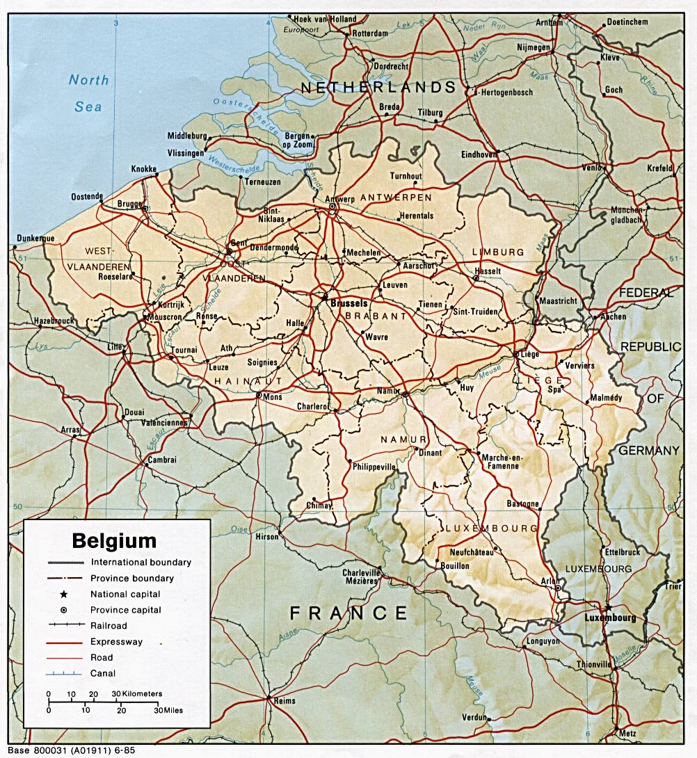
Belgium is located in Western Europe, bordering the North Sea, between France and the Netherlands. Belgium, with an area of 33 990 square kilometres, has three main geographical regions: the coastal plain in the north-west, the central plateau, and the Ardennes uplands in the south-east. The coastal plain consists mainly of sand dunes and polders. Polders are areas of land, close to or below sea level that have been reclaimed from the sea, from which they are protected by dikes or, further inland, by fields that have been drained with canals. The second geographical region, the central plateau, lies further inland. This is a smooth, slowly rising area that has many fertile valleys and is irrigated by many waterways. Here one can also find rougher land, including caves and small gorges.Belgium shares borders with France 620 km, Germany 167 km, Luxembourg 148 km and Netherlands 450 km.

The third geographical region, called the Ardennes, is more rugged than the first two. It is a thickly forested plateau, very rocky and not very good for farming, which extends into northern France and in Germany where it is named Eifel. This is where much of Belgium's wildlife can be found. Belgium's highest point, the Signal de Botrange is located in this region at only 694 metres (2,277 ft). Belgium has relatively few natural lakes, and none of any great size.
Contents |
[edit] General info
Area total: 33,990 km²
land: 30,528 km²
surface water: 250 km² (est)
sea: 3,462 km²
Area comparative
- Australia comparative: one third the size of Tasmania
- Canada comparative: about half the size of Nova Scotia
- United Kingdom comparative: 1.5 times larger than Wales
- United States comparative: about the size of Maryland

Maritime claims:
continental shelf: median line with neighbors
exclusive fishing zone: median line with neighbors (extends about 68 km from coast)
territorial sea: 12 nautical miles
River lengths in Belgium
- See also List of rivers of Belgium.
All of Belgium is drained into the North Sea, except the municipality of Momignies (Macquenoise), which is drained by the Oise river into the English Channel.
Climate: temperate; mild winters, cool summers; rainy, humid, cloudy
Terrain: flat coastal plains in northwest, central rolling hills, forested hills and valleys of the Ardennes Forest in southeast
Natural resources: coal
Land use:
arable land: 28% (2000)
permanent crops: 1% (2000)
permanent pastures: 17% (2000)
forests and woodland: 20% (2000)
other: 34%
Irrigated land: 40 km² (2000)
Natural hazards: flooding is a threat in areas of reclaimed coastal land, protected from the sea by concrete dikes
Environment - current issues: the environment is exposed to intense pressures from human activities: urbanization, dense transportation network, industry, intense animal breeding and crop cultivation; air and water pollution also have repercussions for neighboring countries; uncertainties regarding federal and regional responsibilities (now resolved) have impeded progress in tackling environmental challenges
Environment - international agreements:
party to: Air Pollution, Air Pollution-Sulphur 85, Antarctic-Environmental Protocol, Antarctic Treaty, Biodiversity, Climate Change, Desertification, Endangered Species, Environmental Modification, Hazardous Wastes, Law of the Sea, Marine Dumping, Marine Life Conservation, Nuclear Test Ban, Ozone Layer Protection, Ship Pollution, Tropical Timber 83, Tropical Timber 94, Wetlands
signed, but not ratified: Air Pollution-Nitrogen Oxides, Air Pollution-Persistent Organic Pollutants, Air Pollution-Sulphur 94, Air Pollution-Volatile Organic Compounds, Climate Change-Kyoto Protocol
Geography - note: crossroads of Western Europe; majority of West European capitals within 1,000 km of Brussels which is the seat of both the EU and NATO
Longest Distances: 280 km SE-NW/ 222 km NE-SW
[edit] Climate
The climate is maritime temperate, with significant precipitation in all seasons (Köppen climate classification: Cfb; the average temperature is 3 °C (37°F) in January, and 18° C (64 °F) in July; the average precipitation is 65 millimetres (2.6 inches) in January, and 78 millimetres (3.1 inches) in July).[1]
[edit] Environment
Because of its high population density and location in the centre of Western Europe, Belgium faces serious environmental problems. A 2003 report[2] suggested that the water in Belgium's rivers was of the lowest quality in Europe, and bottom of the 122 countries studied.
[edit] Extreme points

This is a list of the extreme points of Belgium, the points that are farther north, south, east or west than any other location.
- Northernmost point — Dreef, municipality of Hoogstraten, Antwerp
- Southernmost point — Torgny, municipality of Rouvroy, Luxembourg
- Westernmost point — De Panne, West Flanders
- Easternmost point — Krewinkel, municipality of Büllingen, Liège
- Highest point — Signal de Botrange (694 m)
- Lowest point — North Sea (0 m)
The Institut Géographique National calculated that the central point of Belgium lies at coordinates , in Nil-Saint-Vincent-Saint-Martin in the municipality of Walhain.[3]
See also: List of mountains and hills in Belgium

[edit] Surface areas of Belgian provinces
- Antwerp: 2,867 km2
- East Flanders: 2,982 km2
- Flemish Brabant: 2,106 km2
- Hainaut: 3,786 km2
- Liège: 3,862 km2
- Limburg: 2,422 km2
- Luxembourg: 4,440 km2
- Namur: 3,666 km2
- Walloon Brabant: 1,091 km2
- West Flanders: 3,144 km2
To get the total area of Belgium (33,990 km2), the surface of the Brussels-Capital Region (162 km2) and 3,462 km2 of sea territories in the North Sea should be added to the list. Also 2,000 m2 were granted by the Netherlands to Belgium on 29 May 2000 (a piece of land in Zelzate along the Ghent-Terneuzen Canal).
[edit] Cities
[edit] References
- ^ Eurometeo: The meteo at Brussels
- ^ Pearce, Fred (2003-03-05). Sewage-laden Belgian water worst in world. New Scientist. Retrieved on May 9, 2006.
- ^ Centre géographique - Le Site (French). Municipality of Walhain. Retrieved on March 9, 2007.
- Much of the material in this article is adapted from the CIA World Factbook 2000.
- Belgian Federal Govt Online (accessed Dec. 24, 2006)
- Official statistics of Belgium website (accessed Dec. 24, 2006)
[edit] See also
[edit] External links
- Map of Belgium from lib.utexas.edu

