
ಚಿತ್ರ:Plate tectonics map.gif
Wikipedia ಇಂದ
Size of this preview: ೮೦೦ × ೫೨೪ pixels
Full resolution (೧,೨೮೦ × ೮೩೮ pixel, file size: ೩೫೯ KB, MIME type: image/gif)
| | ಈ ಫೈಲು ವಿಕಿಮೀಡಿಯ ಕಾಮನ್ಸ್ನಲ್ಲಿ ಇರುವುದು. ಅಲ್ಲಿನ ವಿವರಣೆ ಪುಟವನ್ನೇ ಕೆಳಗೆ ತೋರಿಸಲಾಗಿದೆ.
|
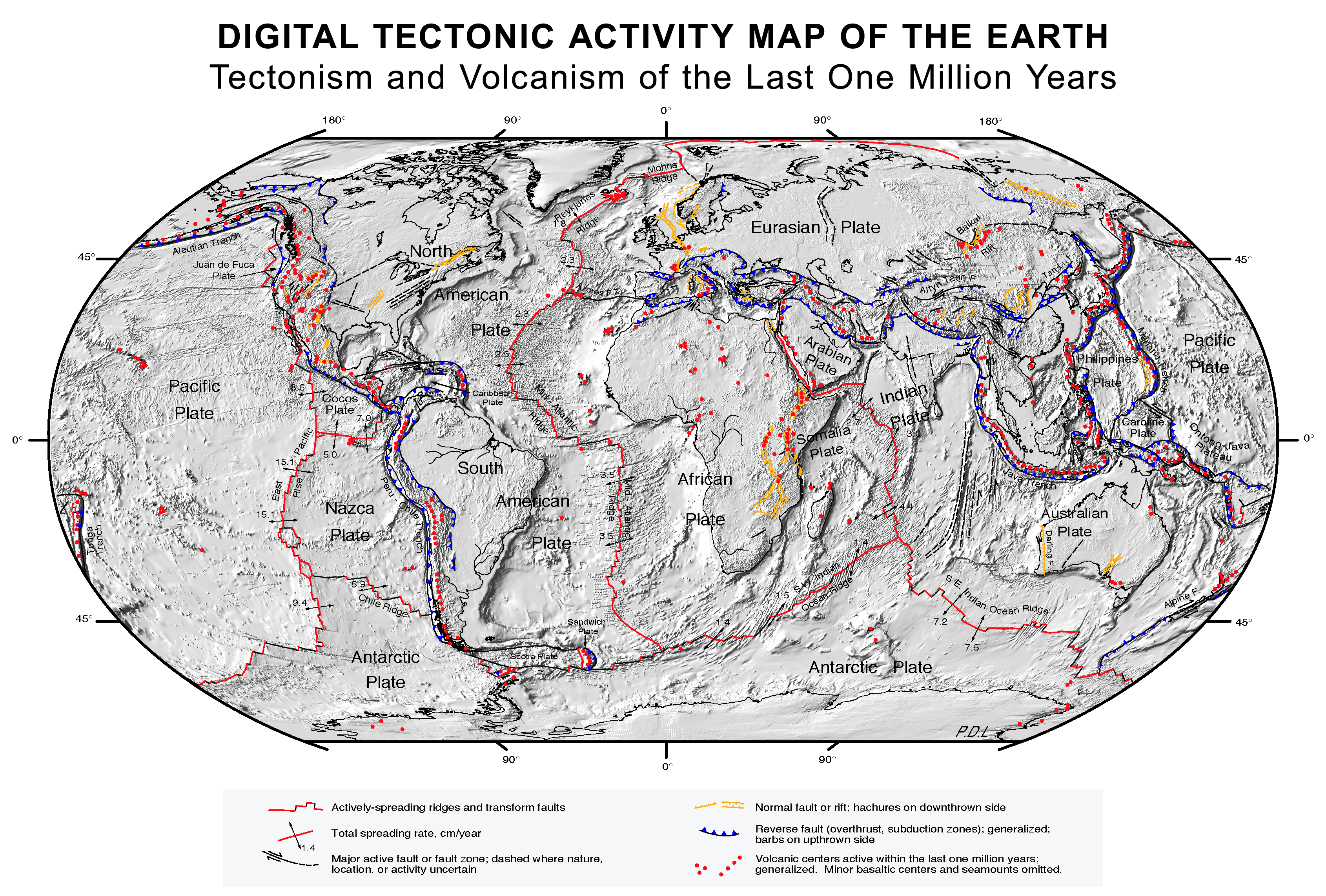
Plate Tectonics map (source)
|
|
This file is in the public domain because it was created by NASA. NASA copyright policy states that "NASA material is not protected by copyright unless noted". (NASA copyright policy page or JPL Image Use Policy).
Deutsch | English | Español | Français | Nederlands | Português | 简体中文 | 繁體中文 | ... |
|
 |
Warnings:
|
ಕಡತದ ಇತಿಹಾಸ
Click on a date/time to view the file as it appeared at that time.
| ದಿನ/ಕಾಲ | ಸದಸ್ಯ | Dimensions | File size | Comment | |
|---|---|---|---|---|---|
| current | ೧೨:೦೮, ೮ ಅಕ್ಟೋಬರ್ ೨೦೦೭ | Geni | ೧,೨೮೦×೮೩೮ | ೩೫೯ KB | rmed nasa logo |
| ೦೩:೧೯, ೧೭ ಫೆಬ್ರುವರಿ ೨೦೦೫ | Quadell | ೧,೨೮೦×೮೩೮ | ೩೬೦ KB | Plate Tectonics map ([http://epod.usra.edu/archive/epodviewer.php3?oid=39392 source]){{PD-USGov-NASA}}Category:World mapsCategory:Plate tectonicsCategory:Continental drift |
Links
ಈ ಕೆಳಗಿನ ಪುಟಗಳು ಈ ಚಿತ್ರಕ್ಕೆ ಸಂಪರ್ಕ ಹೊಂದಿವೆ:

