Imagem:Geostat.gif
Origem: Wikipédia, a enciclopédia livre.

Resolução maior não disponível.
Geostat.gif (300 × 300 pixel, tamanho do ficheiro: 182 KB, tipo MIME: image/gif)
[edit] Summary
| Description |
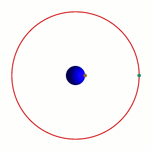
Animation showing the motion of a satellite in a Geostationary Orbit (Green) in relation with a point in the surface of the Earth (Brown), in a 24-hour cycle. Deutsch: geostationäre Umlaufbahn
Suomi: Geostationaarinen rata
Français : Point géostationnaire en vert sur l'orbite vis-à-vis un point brun sur la Terre
Italiano: Il punto verde e quello marrone sono sempre in linea in un orbita geostazionaria
|
|---|---|
| Source |
Own work. Rendered with PovRay-3.0, the pov file is available on demand. |
| Date |
Created 22. Jan. 2006. |
| Author | |
| Permission |
Brandir put it under the GFCL and the CC-BY-SA |
| Other versions | None. |
[edit] Licensing

Ligações
As seguintes páginas apontam para este ficheiro:

