画像:Kazakhstan-East Kazakhstan.png
出典: フリー百科事典『ウィキペディア(Wikipedia)』

No higher resolution available.
Kazakhstan-East_Kazakhstan.png (300 × 171 pixel, file size: 6 キロバイト, MIME type: image/png)
| このファイルはウィキメディア・コモンズから呼び出されたものです。 ページ・ノートへの記入や履歴などの詳細の確認はコモンズの画像説明ページ(ノート/履歴/ログ)を使用してください。 |
[編集]
 ウィキメディア・コモンズの記述
 A vector version of this image ("SVG") is available. For more information about vector graphics, read about Commons transition to SVG. |
 |
[edit] Summary
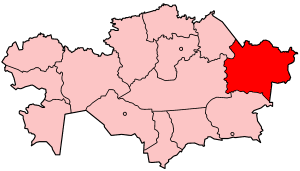
Map of Kazakhstan showing East Kazakhstan province.
Made by User:Golbez based on a PD United Nations map; its borders are different from the available CIA maps, but the UN map is several years newer.
[edit] Licensing
|

リンク
この画像にリンクしているページの一覧:

